You are here: Home > Network List > TA - USArray Transportable Network (new EarthScope stations) Stations List
> Station C22A Vida, MT, USA > Earthquake Result Viewer
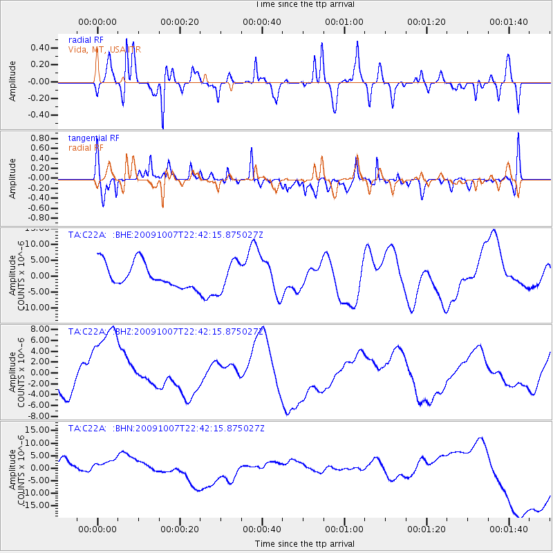
C22A Vida, MT, USA - Earthquake Result Viewer
*The percent match for this event was below the threshold and hence no stack was calculated.
| Earthquake location: |
Santa Cruz Islands |
| Earthquake latitude/longitude: |
-11.5/166.0 |
| Earthquake time(UTC): |
2009/10/07 (280) 22:29:18 GMT |
| Earthquake Depth: |
35 km |
| Earthquake Magnitude: |
5.5 MB |
| Earthquake Catalog/Contributor: |
WHDF/NEIC |
|
| Network: |
TA USArray Transportable Network (new EarthScope stations) |
| Station: |
C22A Vida, MT, USA |
| Lat/Lon: |
47.75 N/105.88 W |
| Elevation: |
745 m |
|
| Distance: |
97.1 deg |
| Az: |
42.826 deg |
| Baz: |
260.842 deg |
| Ray Param: |
$rayparam |
*The percent match for this event was below the threshold and hence was not used in the summary stack. |
|
| Radial Match: |
55.815014 % |
| Radial Bump: |
362 |
| Transverse Match: |
67.84078 % |
| Transverse Bump: |
365 |
| SOD ConfigId: |
2622 |
| Insert Time: |
2010-03-07 00:14:09.060 +0000 |
| GWidth: |
2.5 |
| Max Bumps: |
400 |
| Tol: |
0.001 |
|
Signal To Noise
| Channel | StoN | STA | LTA |
| TA:C22A: :BHZ:20091007T22:42:15.875027Z | 3.984737 | 8.796542E-6 | 2.207559E-6 |
| TA:C22A: :BHN:20091007T22:42:15.875027Z | 0.853714 | 4.7159674E-6 | 5.52406E-6 |
| TA:C22A: :BHE:20091007T22:42:15.875027Z | 1.2255838 | 4.6533937E-6 | 3.7968791E-6 |
| Arrivals |
| Ps | |
| PpPs | |
| PsPs/PpSs | |


