You are here: Home > Network List > TA - USArray Transportable Network (new EarthScope stations) Stations List
> Station C22A Vida, MT, USA > Earthquake Result Viewer
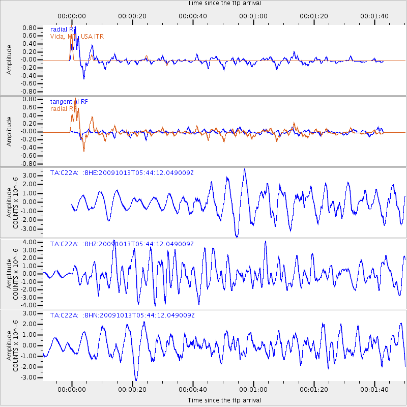
C22A Vida, MT, USA - Earthquake Result Viewer
*The percent match for this event was below the threshold and hence no stack was calculated.
| Earthquake location: |
Fox Islands, Aleutian Islands |
| Earthquake latitude/longitude: |
52.8/-167.0 |
| Earthquake time(UTC): |
2009/10/13 (286) 05:37:23 GMT |
| Earthquake Depth: |
24 km |
| Earthquake Magnitude: |
6.0 MB, 6.1 MS, 6.5 MW, 6.5 MW |
| Earthquake Catalog/Contributor: |
WHDF/NEIC |
|
| Network: |
TA USArray Transportable Network (new EarthScope stations) |
| Station: |
C22A Vida, MT, USA |
| Lat/Lon: |
47.75 N/105.88 W |
| Elevation: |
745 m |
|
| Distance: |
38.4 deg |
| Az: |
72.209 deg |
| Baz: |
300.959 deg |
| Ray Param: |
$rayparam |
*The percent match for this event was below the threshold and hence was not used in the summary stack. |
|
| Radial Match: |
81.22989 % |
| Radial Bump: |
251 |
| Transverse Match: |
54.03418 % |
| Transverse Bump: |
289 |
| SOD ConfigId: |
2622 |
| Insert Time: |
2010-03-07 00:14:11.949 +0000 |
| GWidth: |
2.5 |
| Max Bumps: |
400 |
| Tol: |
0.001 |
|
Signal To Noise
| Channel | StoN | STA | LTA |
| TA:C22A: :BHZ:20091013T05:44:12.049009Z | 3.8793843 | 6.528865E-7 | 1.6829642E-7 |
| TA:C22A: :BHN:20091013T05:44:12.049009Z | 1.175349 | 7.4507375E-7 | 6.33917E-7 |
| TA:C22A: :BHE:20091013T05:44:12.049009Z | 0.89639 | 6.8624263E-7 | 7.6556256E-7 |
| Arrivals |
| Ps | |
| PpPs | |
| PsPs/PpSs | |


