You are here: Home > Network List > TA - USArray Transportable Network (new EarthScope stations) Stations List
> Station C22A Vida, MT, USA > Earthquake Result Viewer
C22A Vida, MT, USA - Earthquake Result Viewer
*The percent match for this event was below the threshold and hence no stack was calculated.
| Earthquake location: |
Samoa Islands Region |
| Earthquake latitude/longitude: |
-15.4/-172.3 |
| Earthquake time(UTC): |
2009/10/19 (292) 22:49:38 GMT |
| Earthquake Depth: |
18 km |
| Earthquake Magnitude: |
6.2 MB, 5.7 MS, 6.0 MW, 5.9 MW |
| Earthquake Catalog/Contributor: |
WHDF/NEIC |
|
| Network: |
TA USArray Transportable Network (new EarthScope stations) |
| Station: |
C22A Vida, MT, USA |
| Lat/Lon: |
47.75 N/105.88 W |
| Elevation: |
745 m |
|
| Distance: |
86.2 deg |
| Az: |
38.296 deg |
| Baz: |
242.36 deg |
| Ray Param: |
$rayparam |
*The percent match for this event was below the threshold and hence was not used in the summary stack. |
|
| Radial Match: |
67.35062 % |
| Radial Bump: |
357 |
| Transverse Match: |
43.893436 % |
| Transverse Bump: |
366 |
| SOD ConfigId: |
2622 |
| Insert Time: |
2010-03-07 00:14:18.405 +0000 |
| GWidth: |
2.5 |
| Max Bumps: |
400 |
| Tol: |
0.001 |
|
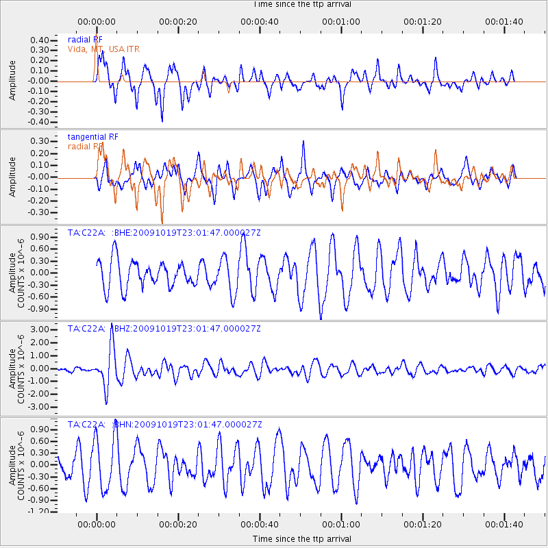
Signal To Noise
| Channel | StoN | STA | LTA |
| TA:C22A: :BHZ:20091019T23:01:47.000027Z | 9.7681465 | 1.5872045E-6 | 1.6248778E-7 |
| TA:C22A: :BHN:20091019T23:01:47.000027Z | 2.0511644 | 6.9808755E-7 | 3.403372E-7 |
| TA:C22A: :BHE:20091019T23:01:47.000027Z | 1.3432753 | 4.4002704E-7 | 3.275777E-7 |
| Arrivals |
| Ps | |
| PpPs | |
| PsPs/PpSs | |


