You are here: Home > Network List > TA - USArray Transportable Network (new EarthScope stations) Stations List
> Station C22A Vida, MT, USA > Earthquake Result Viewer
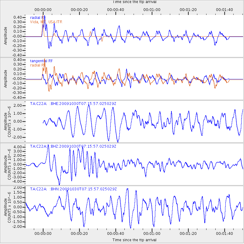
C22A Vida, MT, USA - Earthquake Result Viewer
*The percent match for this event was below the threshold and hence no stack was calculated.
| Earthquake location: |
Ryukyu Islands, Japan |
| Earthquake latitude/longitude: |
29.2/129.8 |
| Earthquake time(UTC): |
2009/10/30 (303) 07:03:39 GMT |
| Earthquake Depth: |
34 km |
| Earthquake Magnitude: |
6.3 MB, 6.8 MS, 6.8 MW, 6.8 MW |
| Earthquake Catalog/Contributor: |
WHDF/NEIC |
|
| Network: |
TA USArray Transportable Network (new EarthScope stations) |
| Station: |
C22A Vida, MT, USA |
| Lat/Lon: |
47.75 N/105.88 W |
| Elevation: |
745 m |
|
| Distance: |
88.5 deg |
| Az: |
33.882 deg |
| Baz: |
313.773 deg |
| Ray Param: |
$rayparam |
*The percent match for this event was below the threshold and hence was not used in the summary stack. |
|
| Radial Match: |
69.15822 % |
| Radial Bump: |
400 |
| Transverse Match: |
44.070637 % |
| Transverse Bump: |
343 |
| SOD ConfigId: |
2622 |
| Insert Time: |
2010-03-07 00:14:22.827 +0000 |
| GWidth: |
2.5 |
| Max Bumps: |
400 |
| Tol: |
0.001 |
|
Signal To Noise
| Channel | StoN | STA | LTA |
| TA:C22A: :BHZ:20091030T07:15:57.025029Z | 11.996251 | 1.956499E-6 | 1.6309254E-7 |
| TA:C22A: :BHN:20091030T07:15:57.025029Z | 1.0909649 | 5.177237E-7 | 4.745558E-7 |
| TA:C22A: :BHE:20091030T07:15:57.025029Z | 1.0645313 | 9.562432E-7 | 8.9827626E-7 |
| Arrivals |
| Ps | |
| PpPs | |
| PsPs/PpSs | |


