You are here: Home > Network List > TA - USArray Transportable Network (new EarthScope stations) Stations List
> Station C22A Vida, MT, USA > Earthquake Result Viewer
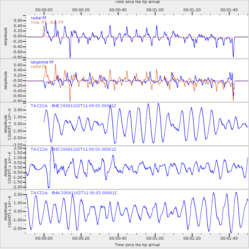
C22A Vida, MT, USA - Earthquake Result Viewer
*The percent match for this event was below the threshold and hence no stack was calculated.
| Earthquake location: |
South Of Tonga Islands |
| Earthquake latitude/longitude: |
-24.1/-175.2 |
| Earthquake time(UTC): |
2009/11/02 (306) 10:47:13 GMT |
| Earthquake Depth: |
9.0 km |
| Earthquake Magnitude: |
6.1 MB, 6.1 MS, 6.2 MW, 6.1 MW |
| Earthquake Catalog/Contributor: |
WHDF/NEIC |
|
| Network: |
TA USArray Transportable Network (new EarthScope stations) |
| Station: |
C22A Vida, MT, USA |
| Lat/Lon: |
47.75 N/105.88 W |
| Elevation: |
745 m |
|
| Distance: |
94.7 deg |
| Az: |
39.302 deg |
| Baz: |
239.04 deg |
| Ray Param: |
$rayparam |
*The percent match for this event was below the threshold and hence was not used in the summary stack. |
|
| Radial Match: |
74.434555 % |
| Radial Bump: |
365 |
| Transverse Match: |
41.13812 % |
| Transverse Bump: |
260 |
| SOD ConfigId: |
2622 |
| Insert Time: |
2010-03-07 00:14:23.522 +0000 |
| GWidth: |
2.5 |
| Max Bumps: |
400 |
| Tol: |
0.001 |
|
Signal To Noise
| Channel | StoN | STA | LTA |
| TA:C22A: :BHZ:20091102T11:00:03.00001Z | 3.3799803 | 1.2850875E-6 | 3.802056E-7 |
| TA:C22A: :BHN:20091102T11:00:03.00001Z | 0.81950957 | 8.2911976E-7 | 1.0117267E-6 |
| TA:C22A: :BHE:20091102T11:00:03.00001Z | 0.6611723 | 6.4617E-7 | 9.773096E-7 |
| Arrivals |
| Ps | |
| PpPs | |
| PsPs/PpSs | |


