You are here: Home > Network List > TA - USArray Transportable Network (new EarthScope stations) Stations List
> Station C22A Vida, MT, USA > Earthquake Result Viewer
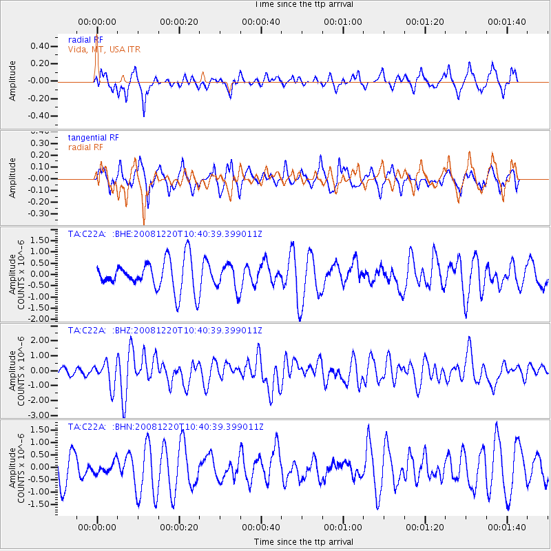
C22A Vida, MT, USA - Earthquake Result Viewer
*The percent match for this event was below the threshold and hence no stack was calculated.
| Earthquake location: |
Off East Coast Of Honshu, Japan |
| Earthquake latitude/longitude: |
36.5/142.4 |
| Earthquake time(UTC): |
2008/12/20 (355) 10:29:23 GMT |
| Earthquake Depth: |
19 km |
| Earthquake Magnitude: |
6.0 MB, 6.3 MS, 6.3 MW, 6.3 MW |
| Earthquake Catalog/Contributor: |
WHDF/NEIC |
|
| Network: |
TA USArray Transportable Network (new EarthScope stations) |
| Station: |
C22A Vida, MT, USA |
| Lat/Lon: |
47.75 N/105.88 W |
| Elevation: |
745 m |
|
| Distance: |
76.3 deg |
| Az: |
40.198 deg |
| Baz: |
309.631 deg |
| Ray Param: |
$rayparam |
*The percent match for this event was below the threshold and hence was not used in the summary stack. |
|
| Radial Match: |
46.025745 % |
| Radial Bump: |
396 |
| Transverse Match: |
53.304314 % |
| Transverse Bump: |
400 |
| SOD ConfigId: |
2658 |
| Insert Time: |
2010-03-07 00:14:47.723 +0000 |
| GWidth: |
2.5 |
| Max Bumps: |
400 |
| Tol: |
0.001 |
|
Signal To Noise
| Channel | StoN | STA | LTA |
| TA:C22A: :BHZ:20081220T10:40:39.399011Z | 2.8376706 | 8.3665344E-7 | 2.9483812E-7 |
| TA:C22A: :BHN:20081220T10:40:39.399011Z | 0.3406508 | 2.3345999E-7 | 6.853352E-7 |
| TA:C22A: :BHE:20081220T10:40:39.399011Z | 0.8478149 | 5.792106E-7 | 6.8318053E-7 |
| Arrivals |
| Ps | |
| PpPs | |
| PsPs/PpSs | |


