You are here: Home > Network List > CI - Caltech Regional Seismic Network Stations List
> Station MPM Manuel Prospect Mine, California, USA > Earthquake Result Viewer
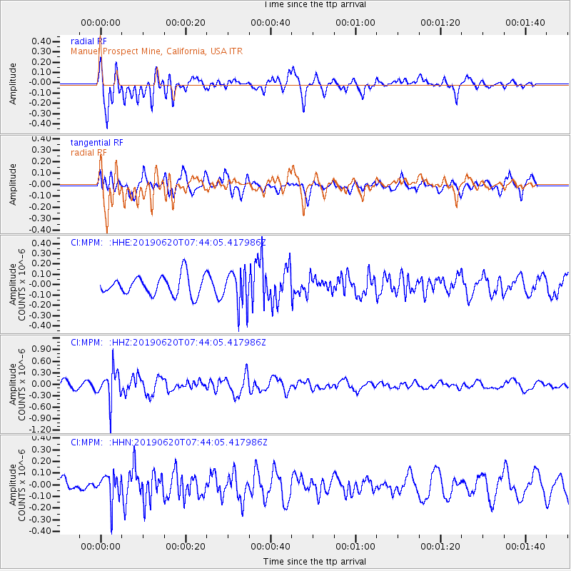
MPM Manuel Prospect Mine, California, USA - Earthquake Result Viewer
*The percent match for this event was below the threshold and hence no stack was calculated.
| Earthquake location: |
Tonga Islands |
| Earthquake latitude/longitude: |
-17.7/-173.7 |
| Earthquake time(UTC): |
2019/06/20 (171) 07:32:57 GMT |
| Earthquake Depth: |
42 km |
| Earthquake Magnitude: |
5.6 mb |
| Earthquake Catalog/Contributor: |
NEIC PDE/us |
|
| Network: |
CI Caltech Regional Seismic Network |
| Station: |
MPM Manuel Prospect Mine, California, USA |
| Lat/Lon: |
36.06 N/117.49 W |
| Elevation: |
185 m |
|
| Distance: |
75.4 deg |
| Az: |
44.12 deg |
| Baz: |
235.001 deg |
| Ray Param: |
$rayparam |
*The percent match for this event was below the threshold and hence was not used in the summary stack. |
|
| Radial Match: |
70.27352 % |
| Radial Bump: |
400 |
| Transverse Match: |
71.85508 % |
| Transverse Bump: |
400 |
| SOD ConfigId: |
18369291 |
| Insert Time: |
2019-07-04 07:35:46.938 +0000 |
| GWidth: |
2.5 |
| Max Bumps: |
400 |
| Tol: |
0.001 |
|
Signal To Noise
| Channel | StoN | STA | LTA |
| CI:MPM: :HHZ:20190620T07:44:05.417986Z | 3.9276235 | 4.039284E-7 | 1.02842954E-7 |
| CI:MPM: :HHN:20190620T07:44:05.417986Z | 1.6384767 | 1.15314805E-7 | 7.037928E-8 |
| CI:MPM: :HHE:20190620T07:44:05.417986Z | 1.8452834 | 1.715372E-7 | 9.2959816E-8 |
| Arrivals |
| Ps | |
| PpPs | |
| PsPs/PpSs | |


