You are here: Home > Network List > TA - USArray Transportable Network (new EarthScope stations) Stations List
> Station C22A Vida, MT, USA > Earthquake Result Viewer
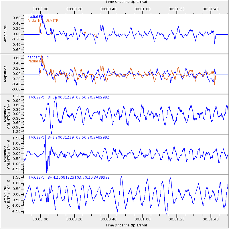
C22A Vida, MT, USA - Earthquake Result Viewer
*The percent match for this event was below the threshold and hence no stack was calculated.
| Earthquake location: |
Afghanistan-Tajikistan Bord Reg. |
| Earthquake latitude/longitude: |
36.4/71.1 |
| Earthquake time(UTC): |
2008/12/29 (364) 03:37:41 GMT |
| Earthquake Depth: |
158 km |
| Earthquake Magnitude: |
5.9 MB, 5.8 MW, 5.8 MW |
| Earthquake Catalog/Contributor: |
WHDF/NEIC |
|
| Network: |
TA USArray Transportable Network (new EarthScope stations) |
| Station: |
C22A Vida, MT, USA |
| Lat/Lon: |
47.75 N/105.88 W |
| Elevation: |
745 m |
|
| Distance: |
96.2 deg |
| Az: |
357.936 deg |
| Baz: |
2.467 deg |
| Ray Param: |
$rayparam |
*The percent match for this event was below the threshold and hence was not used in the summary stack. |
|
| Radial Match: |
45.69303 % |
| Radial Bump: |
400 |
| Transverse Match: |
58.16039 % |
| Transverse Bump: |
400 |
| SOD ConfigId: |
2658 |
| Insert Time: |
2010-03-07 00:14:52.153 +0000 |
| GWidth: |
2.5 |
| Max Bumps: |
400 |
| Tol: |
0.001 |
|
Signal To Noise
| Channel | StoN | STA | LTA |
| TA:C22A: :BHZ:20081229T03:50:20.348999Z | 2.4533699 | 7.623761E-7 | 3.107465E-7 |
| TA:C22A: :BHN:20081229T03:50:20.348999Z | 0.7311649 | 3.708877E-7 | 5.0725595E-7 |
| TA:C22A: :BHE:20081229T03:50:20.348999Z | 0.35048887 | 1.6461355E-7 | 4.696684E-7 |
| Arrivals |
| Ps | |
| PpPs | |
| PsPs/PpSs | |


