You are here: Home > Network List > TA - USArray Transportable Network (new EarthScope stations) Stations List
> Station C22A Vida, MT, USA > Earthquake Result Viewer
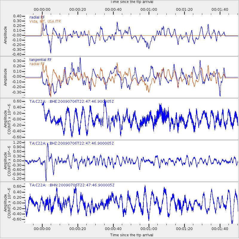
C22A Vida, MT, USA - Earthquake Result Viewer
*The percent match for this event was below the threshold and hence no stack was calculated.
| Earthquake location: |
Southeast Of Ryukyu Islands |
| Earthquake latitude/longitude: |
24.9/128.0 |
| Earthquake time(UTC): |
2009/07/06 (187) 22:35:05 GMT |
| Earthquake Depth: |
10 km |
| Earthquake Magnitude: |
6.1 MB, 5.3 MS, 5.7 MW, 5.7 MW |
| Earthquake Catalog/Contributor: |
WHDF/NEIC |
|
| Network: |
TA USArray Transportable Network (new EarthScope stations) |
| Station: |
C22A Vida, MT, USA |
| Lat/Lon: |
47.75 N/105.88 W |
| Elevation: |
745 m |
|
| Distance: |
93.0 deg |
| Az: |
33.102 deg |
| Baz: |
312.691 deg |
| Ray Param: |
$rayparam |
*The percent match for this event was below the threshold and hence was not used in the summary stack. |
|
| Radial Match: |
57.365005 % |
| Radial Bump: |
400 |
| Transverse Match: |
57.339363 % |
| Transverse Bump: |
400 |
| SOD ConfigId: |
2648 |
| Insert Time: |
2010-03-07 00:14:53.357 +0000 |
| GWidth: |
2.5 |
| Max Bumps: |
400 |
| Tol: |
0.001 |
|
Signal To Noise
| Channel | StoN | STA | LTA |
| TA:C22A: :BHZ:20090706T22:47:46.900005Z | 5.5768595 | 5.576701E-7 | 9.999715E-8 |
| TA:C22A: :BHN:20090706T22:47:46.900005Z | 0.45595258 | 1.2983278E-7 | 2.847506E-7 |
| TA:C22A: :BHE:20090706T22:47:46.900005Z | 0.5611819 | 1.450526E-7 | 2.5847694E-7 |
| Arrivals |
| Ps | |
| PpPs | |
| PsPs/PpSs | |


