You are here: Home > Network List > IU - Global Seismograph Network (GSN - IRIS/USGS) Stations List
> Station RSSD Black Hills, South Dakota, USA > Earthquake Result Viewer
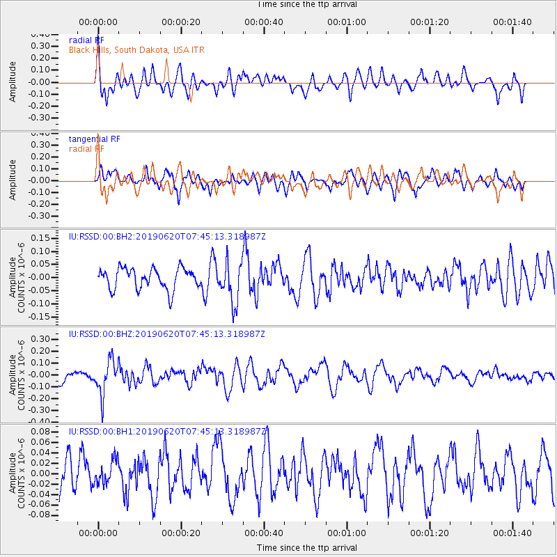
RSSD Black Hills, South Dakota, USA - Earthquake Result Viewer
*The percent match for this event was below the threshold and hence no stack was calculated.
| Earthquake location: |
Tonga Islands |
| Earthquake latitude/longitude: |
-17.7/-173.7 |
| Earthquake time(UTC): |
2019/06/20 (171) 07:32:57 GMT |
| Earthquake Depth: |
42 km |
| Earthquake Magnitude: |
5.6 mb |
| Earthquake Catalog/Contributor: |
NEIC PDE/us |
|
| Network: |
IU Global Seismograph Network (GSN - IRIS/USGS) |
| Station: |
RSSD Black Hills, South Dakota, USA |
| Lat/Lon: |
44.12 N/104.04 W |
| Elevation: |
2090 m |
|
| Distance: |
88.3 deg |
| Az: |
42.506 deg |
| Baz: |
243.445 deg |
| Ray Param: |
$rayparam |
*The percent match for this event was below the threshold and hence was not used in the summary stack. |
|
| Radial Match: |
68.07624 % |
| Radial Bump: |
400 |
| Transverse Match: |
56.31235 % |
| Transverse Bump: |
400 |
| SOD ConfigId: |
18369291 |
| Insert Time: |
2019-07-04 07:37:02.257 +0000 |
| GWidth: |
2.5 |
| Max Bumps: |
400 |
| Tol: |
0.001 |
|
Signal To Noise
| Channel | StoN | STA | LTA |
| IU:RSSD:00:BHZ:20190620T07:45:13.318987Z | 2.8128796 | 1.481695E-7 | 5.2675386E-8 |
| IU:RSSD:00:BH1:20190620T07:45:13.318987Z | 0.4601738 | 2.272504E-8 | 4.9383605E-8 |
| IU:RSSD:00:BH2:20190620T07:45:13.318987Z | 2.015172 | 7.959841E-8 | 3.949956E-8 |
| Arrivals |
| Ps | |
| PpPs | |
| PsPs/PpSs | |


