You are here: Home > Network List > TA - USArray Transportable Network (new EarthScope stations) Stations List
> Station C22A Vida, MT, USA > Earthquake Result Viewer
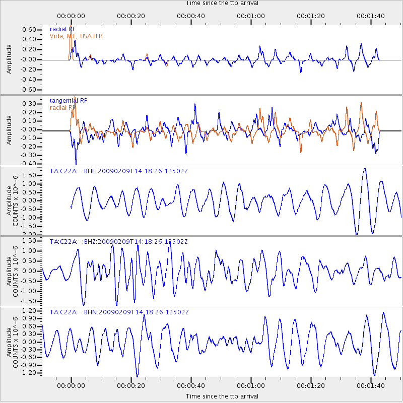
C22A Vida, MT, USA - Earthquake Result Viewer
*The percent match for this event was below the threshold and hence no stack was calculated.
| Earthquake location: |
Near Coast Of Northern Peru |
| Earthquake latitude/longitude: |
-6.6/-81.2 |
| Earthquake time(UTC): |
2009/02/09 (040) 14:09:02 GMT |
| Earthquake Depth: |
15 km |
| Earthquake Magnitude: |
5.5 MB, 5.5 MS, 6.0 MW, 5.9 MW |
| Earthquake Catalog/Contributor: |
WHDF/NEIC |
|
| Network: |
TA USArray Transportable Network (new EarthScope stations) |
| Station: |
C22A Vida, MT, USA |
| Lat/Lon: |
47.75 N/105.88 W |
| Elevation: |
745 m |
|
| Distance: |
58.3 deg |
| Az: |
340.62 deg |
| Baz: |
150.759 deg |
| Ray Param: |
$rayparam |
*The percent match for this event was below the threshold and hence was not used in the summary stack. |
|
| Radial Match: |
52.559845 % |
| Radial Bump: |
270 |
| Transverse Match: |
70.87342 % |
| Transverse Bump: |
400 |
| SOD ConfigId: |
2658 |
| Insert Time: |
2010-03-07 00:15:05.145 +0000 |
| GWidth: |
2.5 |
| Max Bumps: |
400 |
| Tol: |
0.001 |
|
Signal To Noise
| Channel | StoN | STA | LTA |
| TA:C22A: :BHZ:20090209T14:18:26.12502Z | 3.5849736 | 8.991719E-7 | 2.5081687E-7 |
| TA:C22A: :BHN:20090209T14:18:26.12502Z | 0.6077258 | 3.0458818E-7 | 5.011935E-7 |
| TA:C22A: :BHE:20090209T14:18:26.12502Z | 0.40023425 | 2.1662208E-7 | 5.4123825E-7 |
| Arrivals |
| Ps | |
| PpPs | |
| PsPs/PpSs | |


