You are here: Home > Network List > TA - USArray Transportable Network (new EarthScope stations) Stations List
> Station C22A Vida, MT, USA > Earthquake Result Viewer
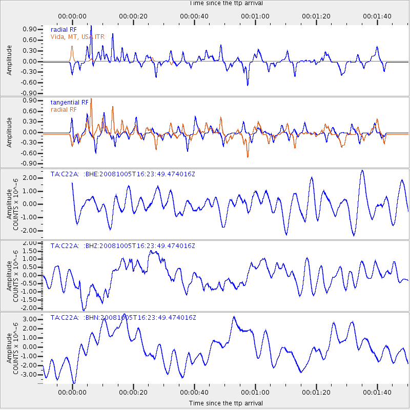
C22A Vida, MT, USA - Earthquake Result Viewer
*The percent match for this event was below the threshold and hence no stack was calculated.
| Earthquake location: |
Tajikistan-Xinjiang Border Reg. |
| Earthquake latitude/longitude: |
39.5/73.9 |
| Earthquake time(UTC): |
2008/10/05 (279) 16:11:10 GMT |
| Earthquake Depth: |
35 km |
| Earthquake Magnitude: |
5.6 MB |
| Earthquake Catalog/Contributor: |
WHDF/NEIC |
|
| Network: |
TA USArray Transportable Network (new EarthScope stations) |
| Station: |
C22A Vida, MT, USA |
| Lat/Lon: |
47.75 N/105.88 W |
| Elevation: |
745 m |
|
| Distance: |
93.1 deg |
| Az: |
359.846 deg |
| Baz: |
0.177 deg |
| Ray Param: |
$rayparam |
*The percent match for this event was below the threshold and hence was not used in the summary stack. |
|
| Radial Match: |
69.728714 % |
| Radial Bump: |
346 |
| Transverse Match: |
57.58087 % |
| Transverse Bump: |
353 |
| SOD ConfigId: |
2556 |
| Insert Time: |
2010-03-07 00:15:06.676 +0000 |
| GWidth: |
2.5 |
| Max Bumps: |
400 |
| Tol: |
0.001 |
|
Signal To Noise
| Channel | StoN | STA | LTA |
| TA:C22A: :BHZ:20081005T16:23:49.474016Z | 3.3165631 | 1.4464631E-6 | 4.3613315E-7 |
| TA:C22A: :BHN:20081005T16:23:49.474016Z | 1.3446314 | 2.2583026E-6 | 1.6794958E-6 |
| TA:C22A: :BHE:20081005T16:23:49.474016Z | 0.8998279 | 6.2590334E-7 | 6.9558115E-7 |
| Arrivals |
| Ps | |
| PpPs | |
| PsPs/PpSs | |


