You are here: Home > Network List > TA - USArray Transportable Network (new EarthScope stations) Stations List
> Station C22A Vida, MT, USA > Earthquake Result Viewer
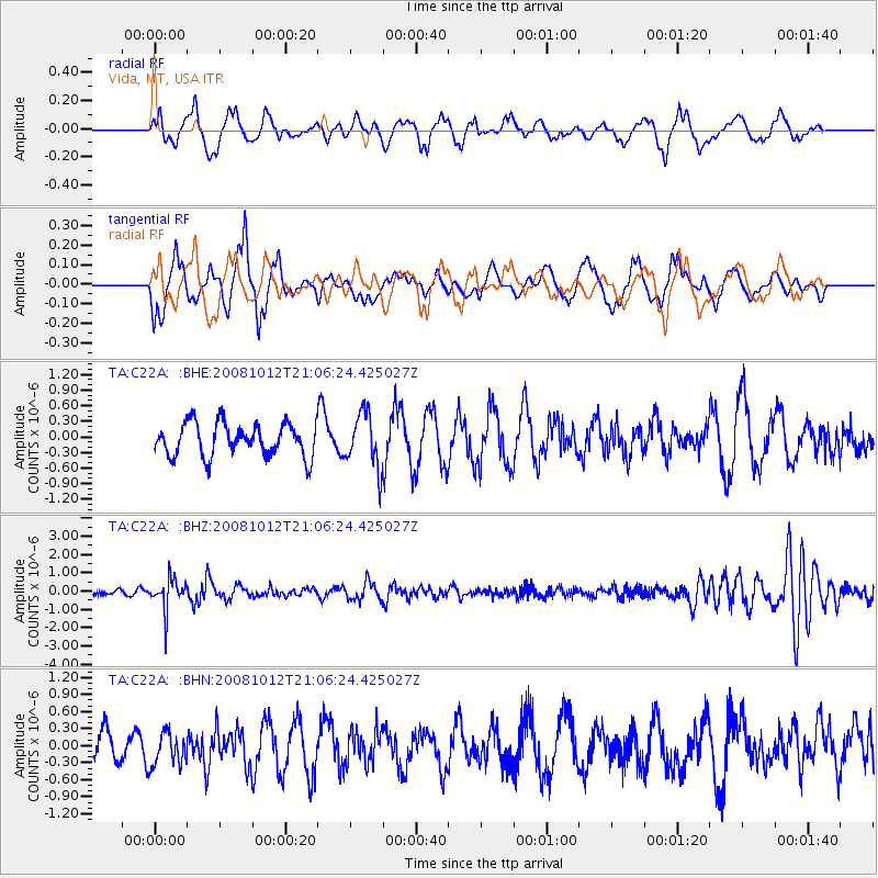
C22A Vida, MT, USA - Earthquake Result Viewer
*The percent match for this event was below the threshold and hence no stack was calculated.
| Earthquake location: |
Southern Bolivia |
| Earthquake latitude/longitude: |
-20.1/-65.0 |
| Earthquake time(UTC): |
2008/10/12 (286) 20:55:41 GMT |
| Earthquake Depth: |
353 km |
| Earthquake Magnitude: |
6.0 MB, 6.2 MW, 6.2 MW |
| Earthquake Catalog/Contributor: |
WHDF/NEIC |
|
| Network: |
TA USArray Transportable Network (new EarthScope stations) |
| Station: |
C22A Vida, MT, USA |
| Lat/Lon: |
47.75 N/105.88 W |
| Elevation: |
745 m |
|
| Distance: |
76.9 deg |
| Az: |
333.01 deg |
| Baz: |
140.809 deg |
| Ray Param: |
$rayparam |
*The percent match for this event was below the threshold and hence was not used in the summary stack. |
|
| Radial Match: |
48.43749 % |
| Radial Bump: |
400 |
| Transverse Match: |
69.023865 % |
| Transverse Bump: |
400 |
| SOD ConfigId: |
2556 |
| Insert Time: |
2010-03-07 00:15:12.398 +0000 |
| GWidth: |
2.5 |
| Max Bumps: |
400 |
| Tol: |
0.001 |
|
Signal To Noise
| Channel | StoN | STA | LTA |
| TA:C22A: :BHZ:20081012T21:06:24.425027Z | 5.5909386 | 8.613676E-7 | 1.5406494E-7 |
| TA:C22A: :BHN:20081012T21:06:24.425027Z | 0.83608913 | 2.9584987E-7 | 3.5384969E-7 |
| TA:C22A: :BHE:20081012T21:06:24.425027Z | 1.6498414 | 5.1978384E-7 | 3.150508E-7 |
| Arrivals |
| Ps | |
| PpPs | |
| PsPs/PpSs | |


