You are here: Home > Network List > TA - USArray Transportable Network (new EarthScope stations) Stations List
> Station C22A Vida, MT, USA > Earthquake Result Viewer
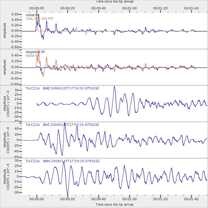
C22A Vida, MT, USA - Earthquake Result Viewer
*The percent match for this event was below the threshold and hence no stack was calculated.
| Earthquake location: |
East Of Kuril Islands |
| Earthquake latitude/longitude: |
46.9/155.2 |
| Earthquake time(UTC): |
2009/01/15 (015) 17:49:39 GMT |
| Earthquake Depth: |
36 km |
| Earthquake Magnitude: |
6.9 MB, 7.5 MS, 7.4 MW, 7.4 MW |
| Earthquake Catalog/Contributor: |
WHDF/NEIC |
|
| Network: |
TA USArray Transportable Network (new EarthScope stations) |
| Station: |
C22A Vida, MT, USA |
| Lat/Lon: |
47.75 N/105.88 W |
| Elevation: |
745 m |
|
| Distance: |
62.3 deg |
| Az: |
48.836 deg |
| Baz: |
310.048 deg |
| Ray Param: |
$rayparam |
*The percent match for this event was below the threshold and hence was not used in the summary stack. |
|
| Radial Match: |
96.53187 % |
| Radial Bump: |
307 |
| Transverse Match: |
90.7248 % |
| Transverse Bump: |
370 |
| SOD ConfigId: |
2834 |
| Insert Time: |
2010-03-07 00:15:17.059 +0000 |
| GWidth: |
2.5 |
| Max Bumps: |
400 |
| Tol: |
0.001 |
|
Signal To Noise
| Channel | StoN | STA | LTA |
| TA:C22A: :BHZ:20090115T17:59:26.975029Z | 34.93947 | 1.2413951E-5 | 3.552988E-7 |
| TA:C22A: :BHN:20090115T17:59:26.975029Z | 5.3102326 | 6.1231553E-6 | 1.153086E-6 |
| TA:C22A: :BHE:20090115T17:59:26.975029Z | 4.0244203 | 7.415431E-6 | 1.8426085E-6 |
| Arrivals |
| Ps | |
| PpPs | |
| PsPs/PpSs | |


