You are here: Home > Network List > TA - USArray Transportable Network (new EarthScope stations) Stations List
> Station C22A Vida, MT, USA > Earthquake Result Viewer
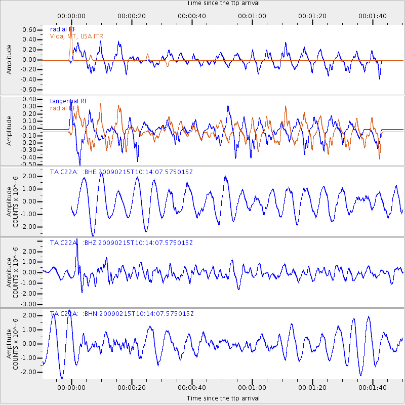
C22A Vida, MT, USA - Earthquake Result Viewer
*The percent match for this event was below the threshold and hence no stack was calculated.
| Earthquake location: |
Near Coast Of Northern Peru |
| Earthquake latitude/longitude: |
-5.9/-80.9 |
| Earthquake time(UTC): |
2009/02/15 (046) 10:04:49 GMT |
| Earthquake Depth: |
21 km |
| Earthquake Magnitude: |
5.8 MB, 5.7 MS, 6.1 MW, 6.1 MW |
| Earthquake Catalog/Contributor: |
WHDF/NEIC |
|
| Network: |
TA USArray Transportable Network (new EarthScope stations) |
| Station: |
C22A Vida, MT, USA |
| Lat/Lon: |
47.75 N/105.88 W |
| Elevation: |
745 m |
|
| Distance: |
57.7 deg |
| Az: |
340.293 deg |
| Baz: |
150.193 deg |
| Ray Param: |
$rayparam |
*The percent match for this event was below the threshold and hence was not used in the summary stack. |
|
| Radial Match: |
45.78208 % |
| Radial Bump: |
316 |
| Transverse Match: |
52.844154 % |
| Transverse Bump: |
321 |
| SOD ConfigId: |
2658 |
| Insert Time: |
2010-03-07 00:15:18.637 +0000 |
| GWidth: |
2.5 |
| Max Bumps: |
400 |
| Tol: |
0.001 |
|
Signal To Noise
| Channel | StoN | STA | LTA |
| TA:C22A: :BHZ:20090215T10:14:07.575015Z | 3.1618946 | 1.0917847E-6 | 3.452945E-7 |
| TA:C22A: :BHN:20090215T10:14:07.575015Z | 1.5430377 | 1.2071033E-6 | 7.822903E-7 |
| TA:C22A: :BHE:20090215T10:14:07.575015Z | 0.57858825 | 7.412637E-7 | 1.2811593E-6 |
| Arrivals |
| Ps | |
| PpPs | |
| PsPs/PpSs | |


