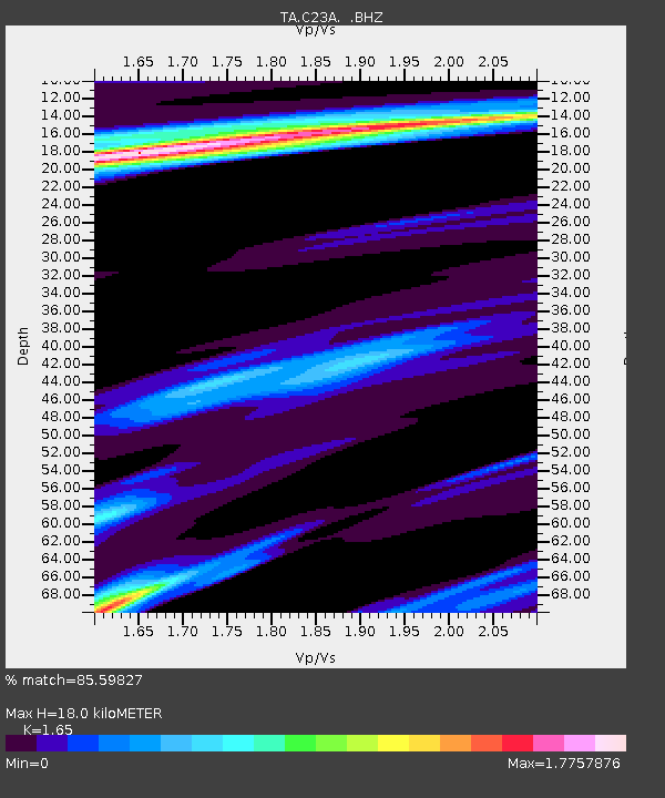
C23A Lambert, MT, USA - Earthquake Result Viewer
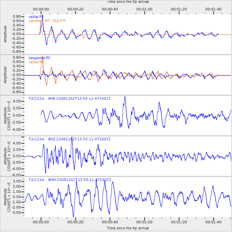
Earthquake location: Andreanof Islands, Aleutian Is.
Earthquake latitude/longitude: 51.6/-174.4
Earthquake time(UTC): 2008/11/02 (307) 13:48:42 GMT
Earthquake Depth: 36 km
Earthquake Magnitude: 5.7 MB, 5.8 MS, 6.1 MW, 6.1 MW
Earthquake Catalog/Contributor: WHDF/NEIC
Network: TA USArray Transportable Network (new EarthScope stations)
Station: C23A Lambert, MT, USA
Lat/Lon: 47.80 N/105.18 W
Elevation: 729 m
Distance: 43.4 deg
Az: 66.501 deg
Baz: 301.861 deg
Ray Param: 0.07249676
Estimated Moho Depth: 18.0 km
Estimated Crust Vp/Vs: 1.65
Assumed Crust Vp: 6.438 km/s
Estimated Crust Vs: 3.902 km/s
Estimated Crust Poisson's Ratio: 0.21
Radial Match: 85.59827 %
Radial Bump: 400
Transverse Match: 61.76486 %
Transverse Bump: 400
SOD ConfigId: 2658
Insert Time: 2010-03-07 00:15:20.728 +0000
GWidth: 2.5
Max Bumps: 400
Tol: 0.001

Signal To Noise

ChannelStoNSTALTA
TA:C23A: :BHZ:20081102T13:56:11.473992Z8.9451922.3302453E-62.6050253E-7
TA:C23A: :BHN:20081102T13:56:11.473992Z1.67165068.081062E-74.8341815E-7
TA:C23A: :BHE:20081102T13:56:11.473992Z1.95332171.36964E-67.011851E-7
Arrivals
Ps2.0 SECOND
PpPs6.9 SECOND
PsPs/PpSs8.9 SECOND