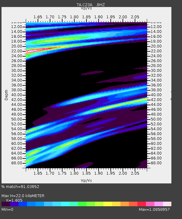
C23A Lambert, MT, USA - Earthquake Result Viewer
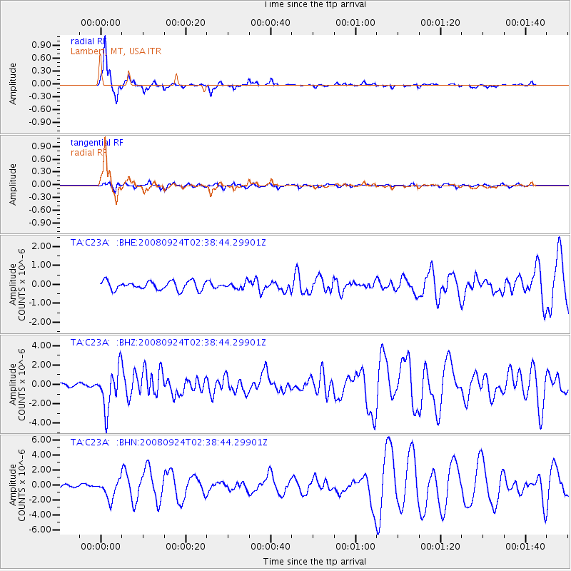
Earthquake location: Off Coast Of Jalisco, Mexico
Earthquake latitude/longitude: 17.6/-105.5
Earthquake time(UTC): 2008/09/24 (268) 02:33:05 GMT
Earthquake Depth: 10 km
Earthquake Magnitude: 5.7 MB, 6.2 MS, 6.4 MW, 6.4 MW
Earthquake Catalog/Contributor: WHDF/NEIC
Network: TA USArray Transportable Network (new EarthScope stations)
Station: C23A Lambert, MT, USA
Lat/Lon: 47.80 N/105.18 W
Elevation: 729 m
Distance: 30.1 deg
Az: 0.424 deg
Baz: 180.6 deg
Ray Param: 0.079416715
Estimated Moho Depth: 22.0 km
Estimated Crust Vp/Vs: 1.61
Assumed Crust Vp: 6.438 km/s
Estimated Crust Vs: 4.011 km/s
Estimated Crust Poisson's Ratio: 0.18
Radial Match: 91.03952 %
Radial Bump: 211
Transverse Match: 71.05453 %
Transverse Bump: 341
SOD ConfigId: 2560
Insert Time: 2010-03-07 00:15:30.803 +0000
GWidth: 2.5
Max Bumps: 400
Tol: 0.001

Signal To Noise

ChannelStoNSTALTA
TA:C23A: :BHZ:20080924T02:38:44.29901Z14.38651852.0739492E-61.4415922E-7
TA:C23A: :BHN:20080924T02:38:44.29901Z9.4512221.3313867E-61.4086926E-7
TA:C23A: :BHE:20080924T02:38:44.29901Z0.74204571.704005E-72.2963613E-7
Arrivals
Ps2.3 SECOND
PpPs8.1 SECOND
PsPs/PpSs10 SECOND