You are here: Home > Network List > TA - USArray Transportable Network (new EarthScope stations) Stations List
> Station B18K Kokolik River, AK, USA > Earthquake Result Viewer
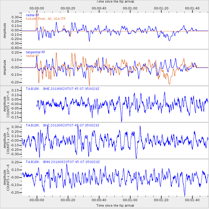
B18K Kokolik River, AK, USA - Earthquake Result Viewer
*The percent match for this event was below the threshold and hence no stack was calculated.
| Earthquake location: |
Tonga Islands |
| Earthquake latitude/longitude: |
-17.7/-173.7 |
| Earthquake time(UTC): |
2019/06/20 (171) 07:32:57 GMT |
| Earthquake Depth: |
42 km |
| Earthquake Magnitude: |
5.6 mb |
| Earthquake Catalog/Contributor: |
NEIC PDE/us |
|
| Network: |
TA USArray Transportable Network (new EarthScope stations) |
| Station: |
B18K Kokolik River, AK, USA |
| Lat/Lon: |
69.36 N/161.80 W |
| Elevation: |
222 m |
|
| Distance: |
87.2 deg |
| Az: |
4.202 deg |
| Baz: |
191.365 deg |
| Ray Param: |
$rayparam |
*The percent match for this event was below the threshold and hence was not used in the summary stack. |
|
| Radial Match: |
45.39448 % |
| Radial Bump: |
400 |
| Transverse Match: |
58.009853 % |
| Transverse Bump: |
400 |
| SOD ConfigId: |
18369291 |
| Insert Time: |
2019-07-04 07:39:13.165 +0000 |
| GWidth: |
2.5 |
| Max Bumps: |
400 |
| Tol: |
0.001 |
|
Signal To Noise
| Channel | StoN | STA | LTA |
| TA:B18K: :BHZ:20190620T07:45:07.950029Z | 2.661369 | 1.6001353E-7 | 6.012452E-8 |
| TA:B18K: :BHN:20190620T07:45:07.950029Z | 1.5278478 | 8.669689E-8 | 5.6744454E-8 |
| TA:B18K: :BHE:20190620T07:45:07.950029Z | 0.9084677 | 3.3624055E-8 | 3.7011834E-8 |
| Arrivals |
| Ps | |
| PpPs | |
| PsPs/PpSs | |


