You are here: Home > Network List > TA - USArray Transportable Network (new EarthScope stations) Stations List
> Station C23A Lambert, MT, USA > Earthquake Result Viewer
C23A Lambert, MT, USA - Earthquake Result Viewer
| Earthquake location: |
Tonga Islands |
| Earthquake latitude/longitude: |
-16.3/-173.5 |
| Earthquake time(UTC): |
2009/10/02 (275) 01:07:39 GMT |
| Earthquake Depth: |
8.0 km |
| Earthquake Magnitude: |
6.1 MB, 6.0 MS, 6.1 MW, 6.1 MW |
| Earthquake Catalog/Contributor: |
WHDF/NEIC |
|
| Network: |
TA USArray Transportable Network (new EarthScope stations) |
| Station: |
C23A Lambert, MT, USA |
| Lat/Lon: |
47.80 N/105.18 W |
| Elevation: |
729 m |
|
| Distance: |
88.1 deg |
| Az: |
38.805 deg |
| Baz: |
243.189 deg |
| Ray Param: |
0.04283579 |
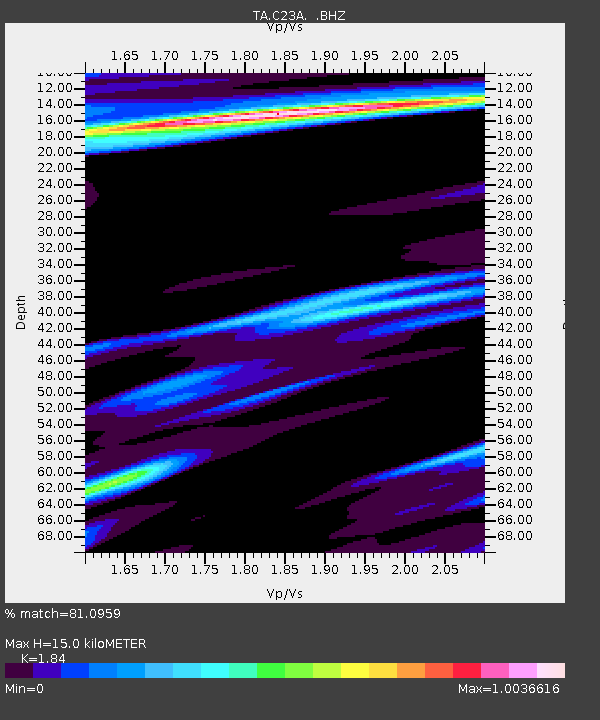
| Estimated Moho Depth: |
15.0 km |
| Estimated Crust Vp/Vs: |
1.84 |
| Assumed Crust Vp: |
6.438 km/s |
| Estimated Crust Vs: |
3.499 km/s |
| Estimated Crust Poisson's Ratio: |
0.29 |
|
| Radial Match: |
81.0959 % |
| Radial Bump: |
317 |
| Transverse Match: |
59.872982 % |
| Transverse Bump: |
382 |
| SOD ConfigId: |
2622 |
| Insert Time: |
2010-03-07 00:15:51.769 +0000 |
| GWidth: |
2.5 |
| Max Bumps: |
400 |
| Tol: |
0.001 |
|
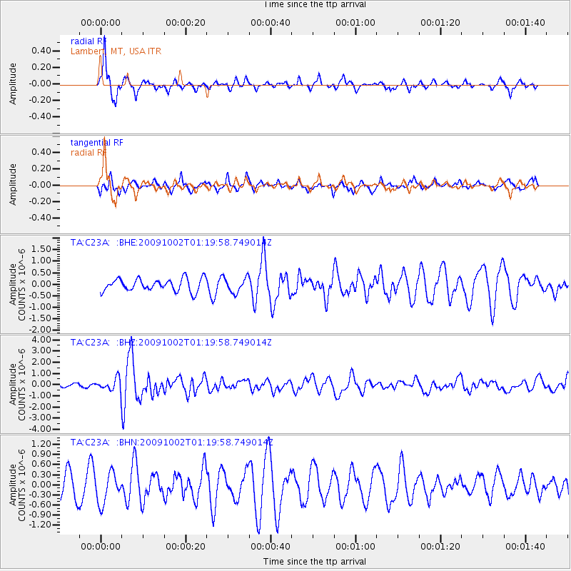
Signal To Noise
| Channel | StoN | STA | LTA |
| TA:C23A: :BHZ:20091002T01:19:58.749014Z | 4.9335065 | 5.787881E-7 | 1.17317796E-7 |
| TA:C23A: :BHN:20091002T01:19:58.749014Z | 1.3844721 | 4.5914527E-7 | 3.3163923E-7 |
| TA:C23A: :BHE:20091002T01:19:58.749014Z | 1.1953001 | 3.2030184E-7 | 2.6796772E-7 |
| Arrivals |
| Ps | 2.0 SECOND |
| PpPs | 6.5 SECOND |
| PsPs/PpSs | 8.5 SECOND |


