You are here: Home > Network List > TA - USArray Transportable Network (new EarthScope stations) Stations List
> Station C23A Lambert, MT, USA > Earthquake Result Viewer
C23A Lambert, MT, USA - Earthquake Result Viewer
| Earthquake location: |
Ryukyu Islands, Japan |
| Earthquake latitude/longitude: |
29.2/129.8 |
| Earthquake time(UTC): |
2009/10/30 (303) 07:03:39 GMT |
| Earthquake Depth: |
34 km |
| Earthquake Magnitude: |
6.3 MB, 6.8 MS, 6.8 MW, 6.8 MW |
| Earthquake Catalog/Contributor: |
WHDF/NEIC |
|
| Network: |
TA USArray Transportable Network (new EarthScope stations) |
| Station: |
C23A Lambert, MT, USA |
| Lat/Lon: |
47.80 N/105.18 W |
| Elevation: |
729 m |
|
| Distance: |
88.8 deg |
| Az: |
33.513 deg |
| Baz: |
314.281 deg |
| Ray Param: |
0.042248636 |
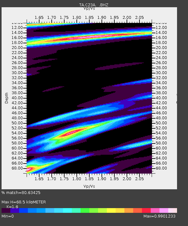
| Estimated Moho Depth: |
68.5 km |
| Estimated Crust Vp/Vs: |
1.60 |
| Assumed Crust Vp: |
6.438 km/s |
| Estimated Crust Vs: |
4.023 km/s |
| Estimated Crust Poisson's Ratio: |
0.18 |
|
| Radial Match: |
80.63425 % |
| Radial Bump: |
291 |
| Transverse Match: |
52.344093 % |
| Transverse Bump: |
305 |
| SOD ConfigId: |
2622 |
| Insert Time: |
2010-03-07 00:15:54.838 +0000 |
| GWidth: |
2.5 |
| Max Bumps: |
400 |
| Tol: |
0.001 |
|

Signal To Noise
| Channel | StoN | STA | LTA |
| TA:C23A: :BHZ:20091030T07:15:58.424016Z | 9.8782015 | 2.5169825E-6 | 2.548017E-7 |
| TA:C23A: :BHN:20091030T07:15:58.424016Z | 1.3362865 | 9.95898E-7 | 7.4527276E-7 |
| TA:C23A: :BHE:20091030T07:15:58.424016Z | 1.842787 | 1.135648E-6 | 6.162665E-7 |
| Arrivals |
| Ps | 6.5 SECOND |
| PpPs | 27 SECOND |
| PsPs/PpSs | 34 SECOND |


