You are here: Home > Network List > TA - USArray Transportable Network (new EarthScope stations) Stations List
> Station C23A Lambert, MT, USA > Earthquake Result Viewer
C23A Lambert, MT, USA - Earthquake Result Viewer
| Earthquake location: |
Hokkaido, Japan Region |
| Earthquake latitude/longitude: |
41.8/143.4 |
| Earthquake time(UTC): |
2009/06/05 (156) 03:30:33 GMT |
| Earthquake Depth: |
29 km |
| Earthquake Magnitude: |
6.0 MB, 6.3 MS, 6.4 MW, 6.4 MW |
| Earthquake Catalog/Contributor: |
WHDF/NEIC |
|
| Network: |
TA USArray Transportable Network (new EarthScope stations) |
| Station: |
C23A Lambert, MT, USA |
| Lat/Lon: |
47.80 N/105.18 W |
| Elevation: |
729 m |
|
| Distance: |
72.1 deg |
| Az: |
41.275 deg |
| Baz: |
312.999 deg |
| Ray Param: |
0.053834006 |
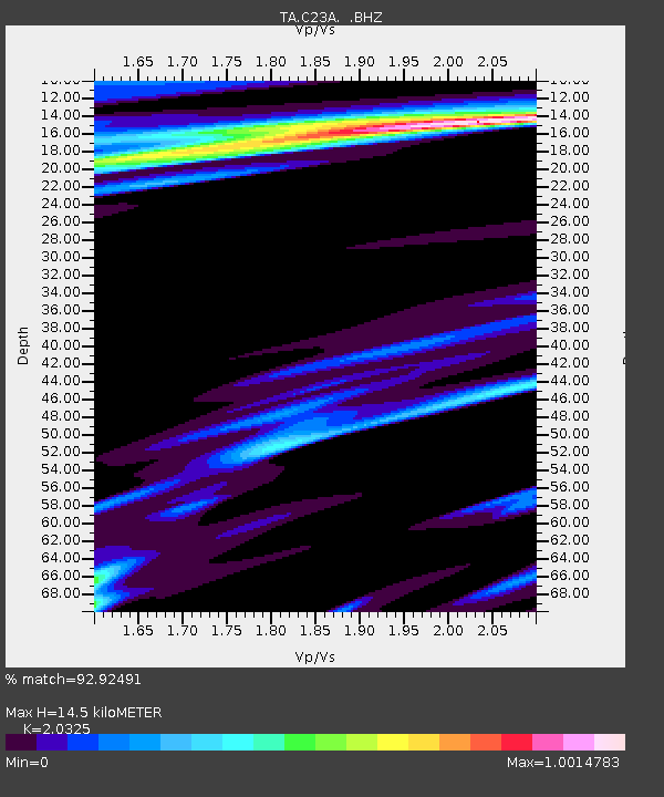
| Estimated Moho Depth: |
14.5 km |
| Estimated Crust Vp/Vs: |
2.03 |
| Assumed Crust Vp: |
6.438 km/s |
| Estimated Crust Vs: |
3.167 km/s |
| Estimated Crust Poisson's Ratio: |
0.34 |
|
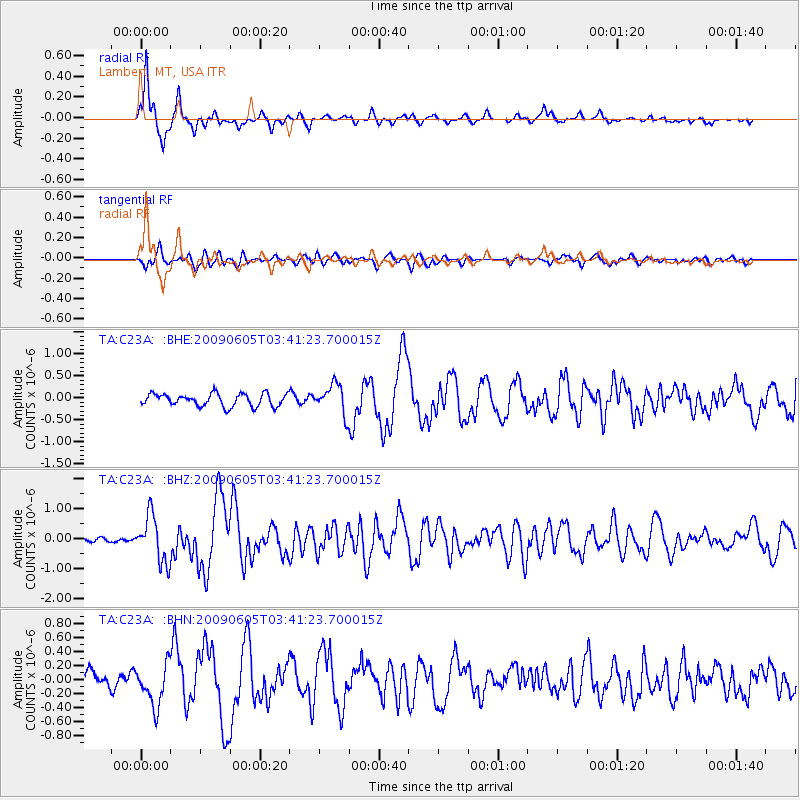
| Radial Match: |
92.92491 % |
| Radial Bump: |
313 |
| Transverse Match: |
63.999428 % |
| Transverse Bump: |
400 |
| SOD ConfigId: |
2648 |
| Insert Time: |
2010-03-07 00:16:02.879 +0000 |
| GWidth: |
2.5 |
| Max Bumps: |
400 |
| Tol: |
0.001 |
|
Signal To Noise
| Channel | StoN | STA | LTA |
| TA:C23A: :BHZ:20090605T03:41:23.700015Z | 9.248529 | 7.687153E-7 | 8.311757E-8 |
| TA:C23A: :BHN:20090605T03:41:23.700015Z | 2.0950022 | 2.9376184E-7 | 1.402203E-7 |
| TA:C23A: :BHE:20090605T03:41:23.700015Z | 2.3736959 | 3.3445403E-7 | 1.4090011E-7 |
| Arrivals |
| Ps | 2.4 SECOND |
| PpPs | 6.6 SECOND |
| PsPs/PpSs | 9.0 SECOND |


