You are here: Home > Network List > TA - USArray Transportable Network (new EarthScope stations) Stations List
> Station M11K Mekoryuk, AK, USA > Earthquake Result Viewer
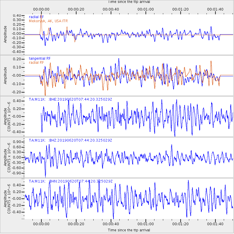
M11K Mekoryuk, AK, USA - Earthquake Result Viewer
*The percent match for this event was below the threshold and hence no stack was calculated.
| Earthquake location: |
Tonga Islands |
| Earthquake latitude/longitude: |
-17.7/-173.7 |
| Earthquake time(UTC): |
2019/06/20 (171) 07:32:57 GMT |
| Earthquake Depth: |
42 km |
| Earthquake Magnitude: |
5.6 mb |
| Earthquake Catalog/Contributor: |
NEIC PDE/us |
|
| Network: |
TA USArray Transportable Network (new EarthScope stations) |
| Station: |
M11K Mekoryuk, AK, USA |
| Lat/Lon: |
60.38 N/166.20 W |
| Elevation: |
3.0 m |
|
| Distance: |
78.0 deg |
| Az: |
3.807 deg |
| Baz: |
187.323 deg |
| Ray Param: |
$rayparam |
*The percent match for this event was below the threshold and hence was not used in the summary stack. |
|
| Radial Match: |
40.94184 % |
| Radial Bump: |
400 |
| Transverse Match: |
54.306454 % |
| Transverse Bump: |
400 |
| SOD ConfigId: |
18369291 |
| Insert Time: |
2019-07-04 07:40:05.138 +0000 |
| GWidth: |
2.5 |
| Max Bumps: |
400 |
| Tol: |
0.001 |
|
Signal To Noise
| Channel | StoN | STA | LTA |
| TA:M11K: :BHZ:20190620T07:44:20.325029Z | 2.0907764 | 4.0946426E-7 | 1.9584316E-7 |
| TA:M11K: :BHN:20190620T07:44:20.325029Z | 1.3578663 | 2.3823138E-7 | 1.7544538E-7 |
| TA:M11K: :BHE:20190620T07:44:20.325029Z | 1.0113035 | 1.6621757E-7 | 1.6435973E-7 |
| Arrivals |
| Ps | |
| PpPs | |
| PsPs/PpSs | |


