You are here: Home > Network List > TA - USArray Transportable Network (new EarthScope stations) Stations List
> Station C23A Lambert, MT, USA > Earthquake Result Viewer
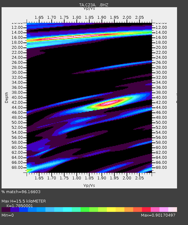
C23A Lambert, MT, USA - Earthquake Result Viewer
| Earthquake location: |
Kuril Islands |
| Earthquake latitude/longitude: |
46.0/151.4 |
| Earthquake time(UTC): |
2009/04/18 (108) 19:17:58 GMT |
| Earthquake Depth: |
35 km |
| Earthquake Magnitude: |
6.3 MB, 6.3 MS, 6.6 MW, 6.4 MW |
| Earthquake Catalog/Contributor: |
WHDF/NEIC |
|
| Network: |
TA USArray Transportable Network (new EarthScope stations) |
| Station: |
C23A Lambert, MT, USA |
| Lat/Lon: |
47.80 N/105.18 W |
| Elevation: |
729 m |
|
| Distance: |
65.1 deg |
| Az: |
46.303 deg |
| Baz: |
311.637 deg |
| Ray Param: |
0.058430824 |
| Estimated Moho Depth: |
15.5 km |
| Estimated Crust Vp/Vs: |
1.79 |
| Assumed Crust Vp: |
6.438 km/s |
| Estimated Crust Vs: |
3.606 km/s |
| Estimated Crust Poisson's Ratio: |
0.27 |
|
| Radial Match: |
96.16603 % |
| Radial Bump: |
225 |
| Transverse Match: |
82.222595 % |
| Transverse Bump: |
400 |
| SOD ConfigId: |
2658 |
| Insert Time: |
2010-03-07 00:16:11.811 +0000 |
| GWidth: |
2.5 |
| Max Bumps: |
400 |
| Tol: |
0.001 |
|

Signal To Noise
| Channel | StoN | STA | LTA |
| TA:C23A: :BHZ:20090418T19:28:05.299019Z | 21.711184 | 3.014877E-6 | 1.3886286E-7 |
| TA:C23A: :BHN:20090418T19:28:05.299019Z | 2.355325 | 5.9102274E-7 | 2.5093047E-7 |
| TA:C23A: :BHE:20090418T19:28:05.299019Z | 1.8910453 | 6.4872427E-7 | 3.430506E-7 |
| Arrivals |
| Ps | 2.0 SECOND |
| PpPs | 6.4 SECOND |
| PsPs/PpSs | 8.4 SECOND |


