You are here: Home > Network List > US - United States National Seismic Network Stations List
> Station EGMT Eagleton, Montana, USA > Earthquake Result Viewer
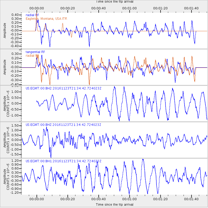
EGMT Eagleton, Montana, USA - Earthquake Result Viewer
*The percent match for this event was below the threshold and hence no stack was calculated.
| Earthquake location: |
Near East Coast Of Honshu, Japan |
| Earthquake latitude/longitude: |
37.2/141.3 |
| Earthquake time(UTC): |
2016/11/23 (328) 21:23:37 GMT |
| Earthquake Depth: |
10 km |
| Earthquake Magnitude: |
5.6 MB |
| Earthquake Catalog/Contributor: |
NEIC PDE/NEIC COMCAT |
|
| Network: |
US United States National Seismic Network |
| Station: |
EGMT Eagleton, Montana, USA |
| Lat/Lon: |
48.02 N/109.75 W |
| Elevation: |
1055 m |
|
| Distance: |
74.2 deg |
| Az: |
41.295 deg |
| Baz: |
308.326 deg |
| Ray Param: |
$rayparam |
*The percent match for this event was below the threshold and hence was not used in the summary stack. |
|
| Radial Match: |
55.72426 % |
| Radial Bump: |
348 |
| Transverse Match: |
46.35062 % |
| Transverse Bump: |
347 |
| SOD ConfigId: |
1858631 |
| Insert Time: |
2016-12-07 21:28:36.615 +0000 |
| GWidth: |
2.5 |
| Max Bumps: |
400 |
| Tol: |
0.001 |
|
Signal To Noise
| Channel | StoN | STA | LTA |
| US:EGMT:00:BHZ:20161123T21:34:42.724023Z | 2.3434396 | 5.7636043E-7 | 2.4594635E-7 |
| US:EGMT:00:BH1:20161123T21:34:42.724023Z | 1.4991155 | 4.1797384E-7 | 2.7881364E-7 |
| US:EGMT:00:BH2:20161123T21:34:42.724023Z | 1.9956373 | 6.31509E-7 | 3.1644478E-7 |
| Arrivals |
| Ps | |
| PpPs | |
| PsPs/PpSs | |


