You are here: Home > Network List > TA - USArray Transportable Network (new EarthScope stations) Stations List
> Station C23A Lambert, MT, USA > Earthquake Result Viewer
C23A Lambert, MT, USA - Earthquake Result Viewer
| Earthquake location: |
Guerrero, Mexico |
| Earthquake latitude/longitude: |
17.0/-99.4 |
| Earthquake time(UTC): |
2009/04/27 (117) 16:46:28 GMT |
| Earthquake Depth: |
35 km |
| Earthquake Magnitude: |
5.7 MB, 5.4 MS, 5.8 MW, 5.8 MW |
| Earthquake Catalog/Contributor: |
WHDF/NEIC |
|
| Network: |
TA USArray Transportable Network (new EarthScope stations) |
| Station: |
C23A Lambert, MT, USA |
| Lat/Lon: |
47.80 N/105.18 W |
| Elevation: |
729 m |
|
| Distance: |
31.0 deg |
| Az: |
352.49 deg |
| Baz: |
169.311 deg |
| Ray Param: |
0.079138204 |
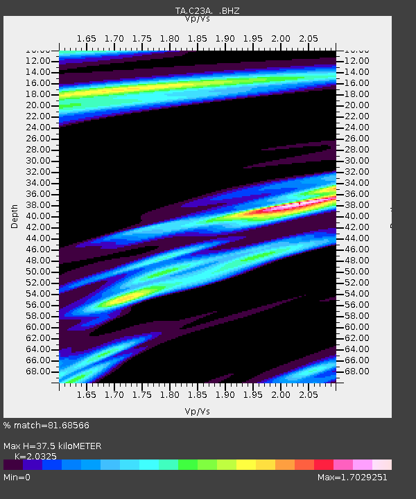
| Estimated Moho Depth: |
37.5 km |
| Estimated Crust Vp/Vs: |
2.03 |
| Assumed Crust Vp: |
6.438 km/s |
| Estimated Crust Vs: |
3.167 km/s |
| Estimated Crust Poisson's Ratio: |
0.34 |
|
| Radial Match: |
81.68566 % |
| Radial Bump: |
387 |
| Transverse Match: |
54.74216 % |
| Transverse Bump: |
400 |
| SOD ConfigId: |
2658 |
| Insert Time: |
2010-03-07 00:16:21.885 +0000 |
| GWidth: |
2.5 |
| Max Bumps: |
400 |
| Tol: |
0.001 |
|
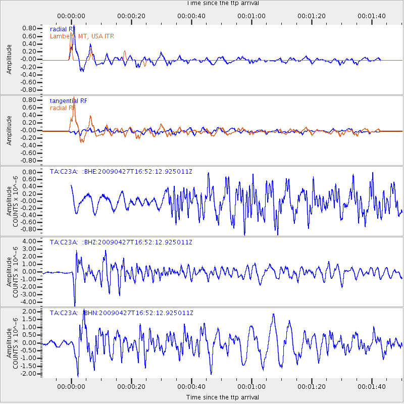
Signal To Noise
| Channel | StoN | STA | LTA |
| TA:C23A: :BHZ:20090427T16:52:12.925011Z | 16.460718 | 1.5123671E-6 | 9.187735E-8 |
| TA:C23A: :BHN:20090427T16:52:12.925011Z | 7.455523 | 1.0403994E-6 | 1.3954747E-7 |
| TA:C23A: :BHE:20090427T16:52:12.925011Z | 1.5286273 | 2.5825815E-7 | 1.6894775E-7 |
| Arrivals |
| Ps | 6.4 SECOND |
| PpPs | 16 SECOND |
| PsPs/PpSs | 23 SECOND |


