You are here: Home > Network List > TA - USArray Transportable Network (new EarthScope stations) Stations List
> Station C23A Lambert, MT, USA > Earthquake Result Viewer
C23A Lambert, MT, USA - Earthquake Result Viewer
| Earthquake location: |
Guatemala |
| Earthquake latitude/longitude: |
14.6/-91.2 |
| Earthquake time(UTC): |
2009/05/03 (123) 16:21:47 GMT |
| Earthquake Depth: |
124 km |
| Earthquake Magnitude: |
5.6 MB, 6.2 MW, 6.2 MW |
| Earthquake Catalog/Contributor: |
WHDF/NEIC |
|
| Network: |
TA USArray Transportable Network (new EarthScope stations) |
| Station: |
C23A Lambert, MT, USA |
| Lat/Lon: |
47.80 N/105.18 W |
| Elevation: |
729 m |
|
| Distance: |
35.1 deg |
| Az: |
343.512 deg |
| Baz: |
155.944 deg |
| Ray Param: |
0.076977424 |
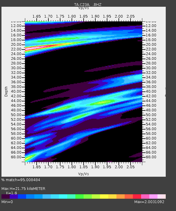
| Estimated Moho Depth: |
21.75 km |
| Estimated Crust Vp/Vs: |
1.60 |
| Assumed Crust Vp: |
6.438 km/s |
| Estimated Crust Vs: |
4.023 km/s |
| Estimated Crust Poisson's Ratio: |
0.18 |
|
| Radial Match: |
95.008484 % |
| Radial Bump: |
245 |
| Transverse Match: |
63.11466 % |
| Transverse Bump: |
400 |
| SOD ConfigId: |
2658 |
| Insert Time: |
2010-03-07 00:16:27.070 +0000 |
| GWidth: |
2.5 |
| Max Bumps: |
400 |
| Tol: |
0.001 |
|
Signal To Noise
| Channel | StoN | STA | LTA |
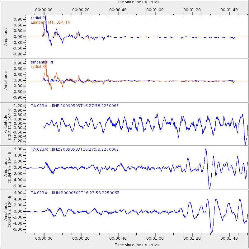
| TA:C23A: :BHZ:20090503T16:27:58.225006Z | 8.051088 | 9.798518E-7 | 1.2170428E-7 |
| TA:C23A: :BHN:20090503T16:27:58.225006Z | 3.614392 | 5.460725E-7 | 1.510828E-7 |
| TA:C23A: :BHE:20090503T16:27:58.225006Z | 1.2673957 | 2.75091E-7 | 2.1705218E-7 |
| Arrivals |
| Ps | 2.2 SECOND |
| PpPs | 8.1 SECOND |
| PsPs/PpSs | 10 SECOND |


