You are here: Home > Network List > TA - USArray Transportable Network (new EarthScope stations) Stations List
> Station C23A Lambert, MT, USA > Earthquake Result Viewer
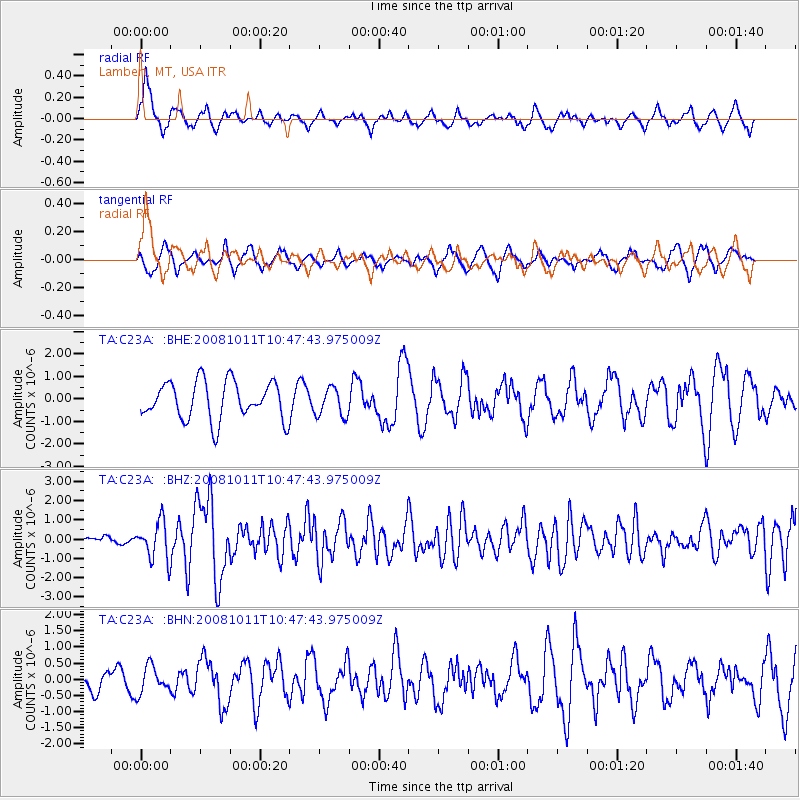
C23A Lambert, MT, USA - Earthquake Result Viewer
*The percent match for this event was below the threshold and hence no stack was calculated.
| Earthquake location: |
Virgin Islands |
| Earthquake latitude/longitude: |
19.2/-64.8 |
| Earthquake time(UTC): |
2008/10/11 (285) 10:40:14 GMT |
| Earthquake Depth: |
23 km |
| Earthquake Magnitude: |
6.1 MB, 5.9 MS, 6.1 MW, 6.0 MW |
| Earthquake Catalog/Contributor: |
WHDF/NEIC |
|
| Network: |
TA USArray Transportable Network (new EarthScope stations) |
| Station: |
C23A Lambert, MT, USA |
| Lat/Lon: |
47.80 N/105.18 W |
| Elevation: |
729 m |
|
| Distance: |
43.4 deg |
| Az: |
320.555 deg |
| Baz: |
117.019 deg |
| Ray Param: |
$rayparam |
*The percent match for this event was below the threshold and hence was not used in the summary stack. |
|
| Radial Match: |
60.18239 % |
| Radial Bump: |
363 |
| Transverse Match: |
54.252243 % |
| Transverse Bump: |
332 |
| SOD ConfigId: |
2556 |
| Insert Time: |
2010-03-07 00:16:36.334 +0000 |
| GWidth: |
2.5 |
| Max Bumps: |
400 |
| Tol: |
0.001 |
|
Signal To Noise
| Channel | StoN | STA | LTA |
| TA:C23A: :BHZ:20081011T10:47:43.975009Z | 4.2695265 | 9.719321E-7 | 2.2764401E-7 |
| TA:C23A: :BHN:20081011T10:47:43.975009Z | 0.6717789 | 4.186375E-7 | 6.231775E-7 |
| TA:C23A: :BHE:20081011T10:47:43.975009Z | 0.7510676 | 6.3173826E-7 | 8.4112037E-7 |
| Arrivals |
| Ps | |
| PpPs | |
| PsPs/PpSs | |


