You are here: Home > Network List > TA - USArray Transportable Network (new EarthScope stations) Stations List
> Station C23A Lambert, MT, USA > Earthquake Result Viewer
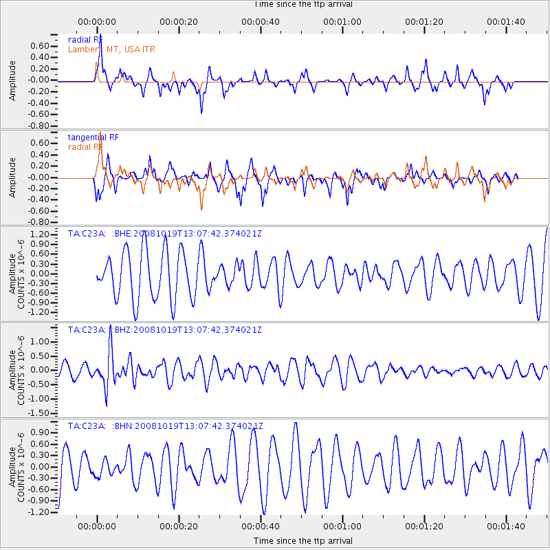
C23A Lambert, MT, USA - Earthquake Result Viewer
*The percent match for this event was below the threshold and hence no stack was calculated.
| Earthquake location: |
Tonga Islands |
| Earthquake latitude/longitude: |
-22.0/-173.7 |
| Earthquake time(UTC): |
2008/10/19 (293) 12:55:05 GMT |
| Earthquake Depth: |
35 km |
| Earthquake Magnitude: |
5.7 MB, 5.3 MS, 5.6 MW, 5.5 MW |
| Earthquake Catalog/Contributor: |
WHDF/NEIC |
|
| Network: |
TA USArray Transportable Network (new EarthScope stations) |
| Station: |
C23A Lambert, MT, USA |
| Lat/Lon: |
47.80 N/105.18 W |
| Elevation: |
729 m |
|
| Distance: |
92.6 deg |
| Az: |
38.9 deg |
| Baz: |
239.841 deg |
| Ray Param: |
$rayparam |
*The percent match for this event was below the threshold and hence was not used in the summary stack. |
|
| Radial Match: |
41.110424 % |
| Radial Bump: |
230 |
| Transverse Match: |
60.264027 % |
| Transverse Bump: |
291 |
| SOD ConfigId: |
2556 |
| Insert Time: |
2010-03-07 00:16:38.123 +0000 |
| GWidth: |
2.5 |
| Max Bumps: |
400 |
| Tol: |
0.001 |
|
Signal To Noise
| Channel | StoN | STA | LTA |
| TA:C23A: :BHZ:20081019T13:07:42.374021Z | 3.9081306 | 6.392371E-7 | 1.6356596E-7 |
| TA:C23A: :BHN:20081019T13:07:42.374021Z | 0.38070425 | 1.9353813E-7 | 5.083687E-7 |
| TA:C23A: :BHE:20081019T13:07:42.374021Z | 0.38252524 | 2.8026997E-7 | 7.326836E-7 |
| Arrivals |
| Ps | |
| PpPs | |
| PsPs/PpSs | |


