You are here: Home > Network List > US - United States National Seismic Network Stations List
> Station WUAZ Wupatki, Arizona, USA > Earthquake Result Viewer
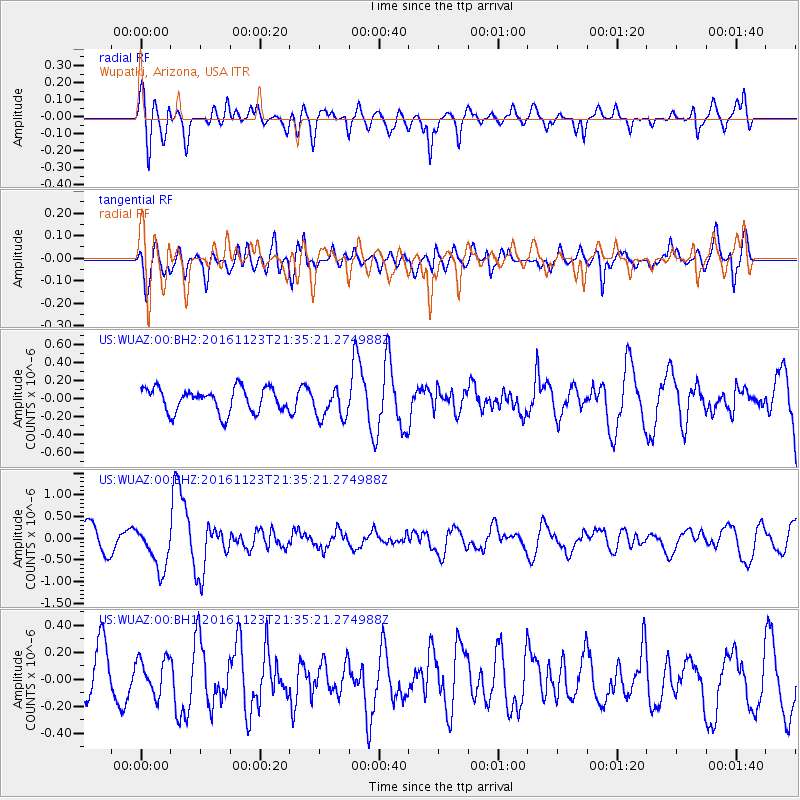
WUAZ Wupatki, Arizona, USA - Earthquake Result Viewer
*The percent match for this event was below the threshold and hence no stack was calculated.
| Earthquake location: |
Near East Coast Of Honshu, Japan |
| Earthquake latitude/longitude: |
37.2/141.3 |
| Earthquake time(UTC): |
2016/11/23 (328) 21:23:37 GMT |
| Earthquake Depth: |
10 km |
| Earthquake Magnitude: |
5.6 MB |
| Earthquake Catalog/Contributor: |
NEIC PDE/NEIC COMCAT |
|
| Network: |
US United States National Seismic Network |
| Station: |
WUAZ Wupatki, Arizona, USA |
| Lat/Lon: |
35.52 N/111.37 W |
| Elevation: |
1592 m |
|
| Distance: |
81.1 deg |
| Az: |
52.021 deg |
| Baz: |
309.551 deg |
| Ray Param: |
$rayparam |
*The percent match for this event was below the threshold and hence was not used in the summary stack. |
|
| Radial Match: |
56.87826 % |
| Radial Bump: |
400 |
| Transverse Match: |
66.51317 % |
| Transverse Bump: |
400 |
| SOD ConfigId: |
1858631 |
| Insert Time: |
2016-12-07 21:29:11.792 +0000 |
| GWidth: |
2.5 |
| Max Bumps: |
400 |
| Tol: |
0.001 |
|
Signal To Noise
| Channel | StoN | STA | LTA |
| US:WUAZ:00:BHZ:20161123T21:35:21.274988Z | 2.2244744 | 4.8816935E-7 | 2.1945377E-7 |
| US:WUAZ:00:BH1:20161123T21:35:21.274988Z | 1.0030347 | 1.3135225E-7 | 1.3095485E-7 |
| US:WUAZ:00:BH2:20161123T21:35:21.274988Z | 1.2959692 | 1.706242E-7 | 1.316576E-7 |
| Arrivals |
| Ps | |
| PpPs | |
| PsPs/PpSs | |


