You are here: Home > Network List > TA - USArray Transportable Network (new EarthScope stations) Stations List
> Station C23A Lambert, MT, USA > Earthquake Result Viewer
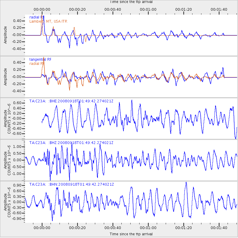
C23A Lambert, MT, USA - Earthquake Result Viewer
*The percent match for this event was below the threshold and hence no stack was calculated.
| Earthquake location: |
Central East Pacific Rise |
| Earthquake latitude/longitude: |
-4.6/-106.0 |
| Earthquake time(UTC): |
2008/09/18 (262) 01:41:02 GMT |
| Earthquake Depth: |
10 km |
| Earthquake Magnitude: |
5.5 MB, 5.7 MS, 6.0 MW, 6.0 MW |
| Earthquake Catalog/Contributor: |
WHDF/NEIC |
|
| Network: |
TA USArray Transportable Network (new EarthScope stations) |
| Station: |
C23A Lambert, MT, USA |
| Lat/Lon: |
47.80 N/105.18 W |
| Elevation: |
729 m |
|
| Distance: |
52.1 deg |
| Az: |
0.696 deg |
| Baz: |
181.03 deg |
| Ray Param: |
$rayparam |
*The percent match for this event was below the threshold and hence was not used in the summary stack. |
|
| Radial Match: |
66.60485 % |
| Radial Bump: |
395 |
| Transverse Match: |
57.490425 % |
| Transverse Bump: |
400 |
| SOD ConfigId: |
2560 |
| Insert Time: |
2010-03-07 00:16:41.327 +0000 |
| GWidth: |
2.5 |
| Max Bumps: |
400 |
| Tol: |
0.001 |
|
Signal To Noise
| Channel | StoN | STA | LTA |
| TA:C23A: :BHZ:20080918T01:49:42.274021Z | 3.4649906 | 4.78685E-7 | 1.3814902E-7 |
| TA:C23A: :BHN:20080918T01:49:42.274021Z | 1.3573169 | 2.6684208E-7 | 1.9659527E-7 |
| TA:C23A: :BHE:20080918T01:49:42.274021Z | 0.94327784 | 2.8929173E-7 | 3.0668772E-7 |
| Arrivals |
| Ps | |
| PpPs | |
| PsPs/PpSs | |


