You are here: Home > Network List > TA - USArray Transportable Network (new EarthScope stations) Stations List
> Station C23A Lambert, MT, USA > Earthquake Result Viewer
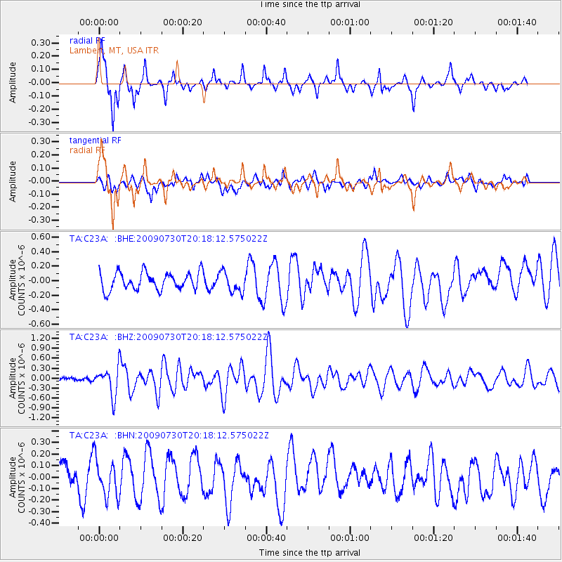
C23A Lambert, MT, USA - Earthquake Result Viewer
*The percent match for this event was below the threshold and hence no stack was calculated.
| Earthquake location: |
Tonga Islands |
| Earthquake latitude/longitude: |
-20.8/-174.3 |
| Earthquake time(UTC): |
2009/07/30 (211) 20:05:34 GMT |
| Earthquake Depth: |
10 km |
| Earthquake Magnitude: |
5.9 MB, 5.7 MS, 5.8 MW, 5.7 MW |
| Earthquake Catalog/Contributor: |
WHDF/NEIC |
|
| Network: |
TA USArray Transportable Network (new EarthScope stations) |
| Station: |
C23A Lambert, MT, USA |
| Lat/Lon: |
47.80 N/105.18 W |
| Elevation: |
729 m |
|
| Distance: |
92.1 deg |
| Az: |
39.056 deg |
| Baz: |
240.946 deg |
| Ray Param: |
$rayparam |
*The percent match for this event was below the threshold and hence was not used in the summary stack. |
|
| Radial Match: |
78.285095 % |
| Radial Bump: |
360 |
| Transverse Match: |
58.720257 % |
| Transverse Bump: |
400 |
| SOD ConfigId: |
2622 |
| Insert Time: |
2010-03-07 00:16:48.158 +0000 |
| GWidth: |
2.5 |
| Max Bumps: |
400 |
| Tol: |
0.001 |
|
Signal To Noise
| Channel | StoN | STA | LTA |
| TA:C23A: :BHZ:20090730T20:18:12.575022Z | 5.4628143 | 4.428149E-7 | 8.1059845E-8 |
| TA:C23A: :BHN:20090730T20:18:12.575022Z | 1.3700665 | 1.4751399E-7 | 1.07669216E-7 |
| TA:C23A: :BHE:20090730T20:18:12.575022Z | 1.1747433 | 1.427378E-7 | 1.2150552E-7 |
| Arrivals |
| Ps | |
| PpPs | |
| PsPs/PpSs | |


