You are here: Home > Network List > UU - University of Utah Regional Network Stations List
> Station KNB Kanab, UT, USA > Earthquake Result Viewer
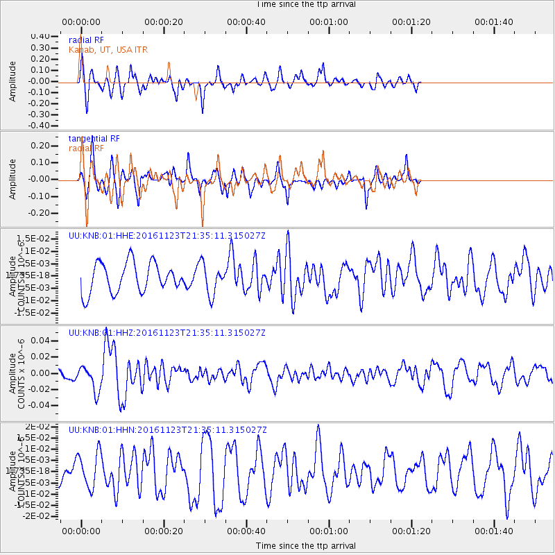
KNB Kanab, UT, USA - Earthquake Result Viewer
*The percent match for this event was below the threshold and hence no stack was calculated.
| Earthquake location: |
Near East Coast Of Honshu, Japan |
| Earthquake latitude/longitude: |
37.2/141.3 |
| Earthquake time(UTC): |
2016/11/23 (328) 21:23:37 GMT |
| Earthquake Depth: |
10 km |
| Earthquake Magnitude: |
5.6 MB |
| Earthquake Catalog/Contributor: |
NEIC PDE/NEIC COMCAT |
|
| Network: |
UU University of Utah Regional Network |
| Station: |
KNB Kanab, UT, USA |
| Lat/Lon: |
37.02 N/112.82 W |
| Elevation: |
1715 m |
|
| Distance: |
79.3 deg |
| Az: |
51.591 deg |
| Baz: |
308.625 deg |
| Ray Param: |
$rayparam |
*The percent match for this event was below the threshold and hence was not used in the summary stack. |
|
| Radial Match: |
74.94256 % |
| Radial Bump: |
335 |
| Transverse Match: |
51.20582 % |
| Transverse Bump: |
297 |
| SOD ConfigId: |
1858631 |
| Insert Time: |
2016-12-07 21:29:35.193 +0000 |
| GWidth: |
2.5 |
| Max Bumps: |
400 |
| Tol: |
0.001 |
|
Signal To Noise
| Channel | StoN | STA | LTA |
| UU:KNB:01:HHZ:20161123T21:35:11.315027Z | 3.5385392 | 1.6045913E-8 | 4.5346153E-9 |
| UU:KNB:01:HHN:20161123T21:35:11.315027Z | 0.97239274 | 8.0420595E-9 | 8.270382E-9 |
| UU:KNB:01:HHE:20161123T21:35:11.315027Z | 1.0279012 | 6.168644E-9 | 6.0012035E-9 |
| Arrivals |
| Ps | |
| PpPs | |
| PsPs/PpSs | |


