You are here: Home > Network List > TA - USArray Transportable Network (new EarthScope stations) Stations List
> Station C23A Lambert, MT, USA > Earthquake Result Viewer
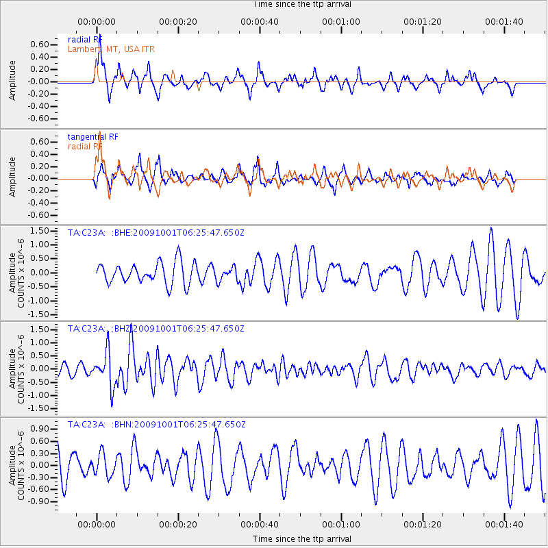
C23A Lambert, MT, USA - Earthquake Result Viewer
*The percent match for this event was below the threshold and hence no stack was calculated.
| Earthquake location: |
Tonga Islands |
| Earthquake latitude/longitude: |
-15.4/-173.3 |
| Earthquake time(UTC): |
2009/10/01 (274) 06:13:32 GMT |
| Earthquake Depth: |
10 km |
| Earthquake Magnitude: |
5.6 MB, 5.7 MS, 5.8 MW, 5.7 MW |
| Earthquake Catalog/Contributor: |
WHDF/NEIC |
|
| Network: |
TA USArray Transportable Network (new EarthScope stations) |
| Station: |
C23A Lambert, MT, USA |
| Lat/Lon: |
47.80 N/105.18 W |
| Elevation: |
729 m |
|
| Distance: |
87.2 deg |
| Az: |
38.762 deg |
| Baz: |
243.616 deg |
| Ray Param: |
$rayparam |
*The percent match for this event was below the threshold and hence was not used in the summary stack. |
|
| Radial Match: |
55.47114 % |
| Radial Bump: |
336 |
| Transverse Match: |
64.407295 % |
| Transverse Bump: |
400 |
| SOD ConfigId: |
2622 |
| Insert Time: |
2010-03-07 00:16:56.118 +0000 |
| GWidth: |
2.5 |
| Max Bumps: |
400 |
| Tol: |
0.001 |
|
Signal To Noise
| Channel | StoN | STA | LTA |
| TA:C23A: :BHZ:20091001T06:25:47.650Z | 4.070497 | 6.6692354E-7 | 1.6384327E-7 |
| TA:C23A: :BHN:20091001T06:25:47.650Z | 0.55514956 | 2.757501E-7 | 4.967132E-7 |
| TA:C23A: :BHE:20091001T06:25:47.650Z | 0.65518963 | 2.4566668E-7 | 3.7495508E-7 |
| Arrivals |
| Ps | |
| PpPs | |
| PsPs/PpSs | |


