You are here: Home > Network List > TA - USArray Transportable Network (new EarthScope stations) Stations List
> Station C23A Lambert, MT, USA > Earthquake Result Viewer
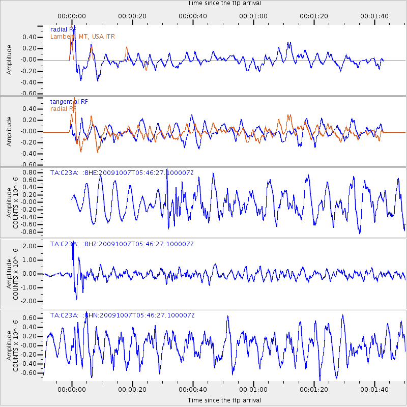
C23A Lambert, MT, USA - Earthquake Result Viewer
*The percent match for this event was below the threshold and hence no stack was calculated.
| Earthquake location: |
Rat Islands, Aleutian Islands |
| Earthquake latitude/longitude: |
52.2/178.1 |
| Earthquake time(UTC): |
2009/10/07 (280) 05:38:37 GMT |
| Earthquake Depth: |
138 km |
| Earthquake Magnitude: |
5.6 MB, 5.6 MW, 5.6 MW |
| Earthquake Catalog/Contributor: |
WHDF/NEIC |
|
| Network: |
TA USArray Transportable Network (new EarthScope stations) |
| Station: |
C23A Lambert, MT, USA |
| Lat/Lon: |
47.80 N/105.18 W |
| Elevation: |
729 m |
|
| Distance: |
47.4 deg |
| Az: |
63.066 deg |
| Baz: |
305.442 deg |
| Ray Param: |
$rayparam |
*The percent match for this event was below the threshold and hence was not used in the summary stack. |
|
| Radial Match: |
53.42265 % |
| Radial Bump: |
400 |
| Transverse Match: |
60.8983 % |
| Transverse Bump: |
400 |
| SOD ConfigId: |
2622 |
| Insert Time: |
2010-03-07 00:16:56.683 +0000 |
| GWidth: |
2.5 |
| Max Bumps: |
400 |
| Tol: |
0.001 |
|
Signal To Noise
| Channel | StoN | STA | LTA |
| TA:C23A: :BHZ:20091007T05:46:27.100007Z | 9.305251 | 9.522853E-7 | 1.02338475E-7 |
| TA:C23A: :BHN:20091007T05:46:27.100007Z | 0.88789356 | 3.3986646E-7 | 3.8277838E-7 |
| TA:C23A: :BHE:20091007T05:46:27.100007Z | 1.0115575 | 3.513021E-7 | 3.4728833E-7 |
| Arrivals |
| Ps | |
| PpPs | |
| PsPs/PpSs | |


