You are here: Home > Network List > TA - USArray Transportable Network (new EarthScope stations) Stations List
> Station C23A Lambert, MT, USA > Earthquake Result Viewer
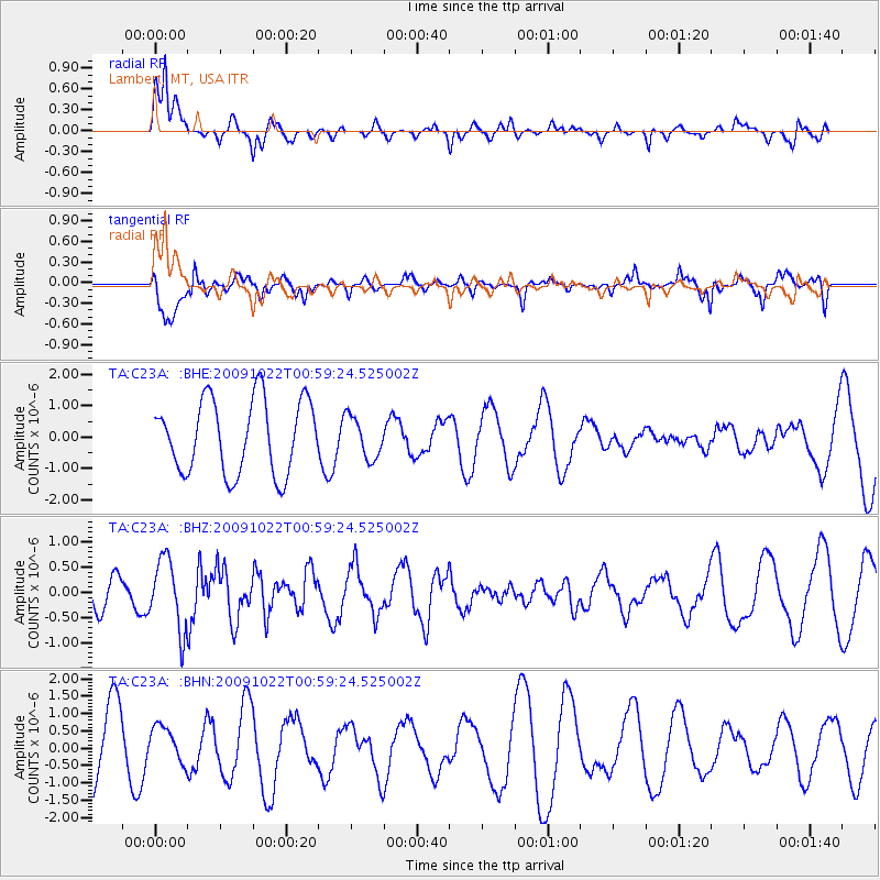
C23A Lambert, MT, USA - Earthquake Result Viewer
*The percent match for this event was below the threshold and hence no stack was calculated.
| Earthquake location: |
South Of Panama |
| Earthquake latitude/longitude: |
6.7/-82.6 |
| Earthquake time(UTC): |
2009/10/22 (295) 00:51:39 GMT |
| Earthquake Depth: |
18 km |
| Earthquake Magnitude: |
5.5 MB, 5.4 MS, 5.9 MW, 5.9 MW |
| Earthquake Catalog/Contributor: |
WHDF/NEIC |
|
| Network: |
TA USArray Transportable Network (new EarthScope stations) |
| Station: |
C23A Lambert, MT, USA |
| Lat/Lon: |
47.80 N/105.18 W |
| Elevation: |
729 m |
|
| Distance: |
45.2 deg |
| Az: |
338.597 deg |
| Baz: |
147.477 deg |
| Ray Param: |
$rayparam |
*The percent match for this event was below the threshold and hence was not used in the summary stack. |
|
| Radial Match: |
56.124557 % |
| Radial Bump: |
325 |
| Transverse Match: |
60.259804 % |
| Transverse Bump: |
342 |
| SOD ConfigId: |
2622 |
| Insert Time: |
2010-03-07 00:17:00.437 +0000 |
| GWidth: |
2.5 |
| Max Bumps: |
400 |
| Tol: |
0.001 |
|
Signal To Noise
| Channel | StoN | STA | LTA |
| TA:C23A: :BHZ:20091022T00:59:24.525002Z | 2.992034 | 6.9888193E-7 | 2.3358089E-7 |
| TA:C23A: :BHN:20091022T00:59:24.525002Z | 0.38529313 | 5.075095E-7 | 1.3172037E-6 |
| TA:C23A: :BHE:20091022T00:59:24.525002Z | 0.5643557 | 6.574244E-7 | 1.1649114E-6 |
| Arrivals |
| Ps | |
| PpPs | |
| PsPs/PpSs | |


