You are here: Home > Network List > TS - TERRAscope (Southern California Seismic Network) Stations List
> Station GSC Goldston, California, USA > Earthquake Result Viewer
GSC Goldston, California, USA - Earthquake Result Viewer
| Earthquake location: |
Vanuatu Islands |
| Earthquake latitude/longitude: |
-14.7/167.3 |
| Earthquake time(UTC): |
1996/03/17 (077) 14:48:56 GMT |
| Earthquake Depth: |
164 km |
| Earthquake Magnitude: |
5.8 MB, 6.0 MS, 6.7 UNKNOWN, 6.1 MS |
| Earthquake Catalog/Contributor: |
WHDF/NEIC |
|
| Network: |
TS TERRAscope (Southern California Seismic Network) |
| Station: |
GSC Goldston, California, USA |
| Lat/Lon: |
35.30 N/116.81 W |
| Elevation: |
990 m |
|
| Distance: |
87.3 deg |
| Az: |
52.578 deg |
| Baz: |
249.978 deg |
| Ray Param: |
0.043083068 |
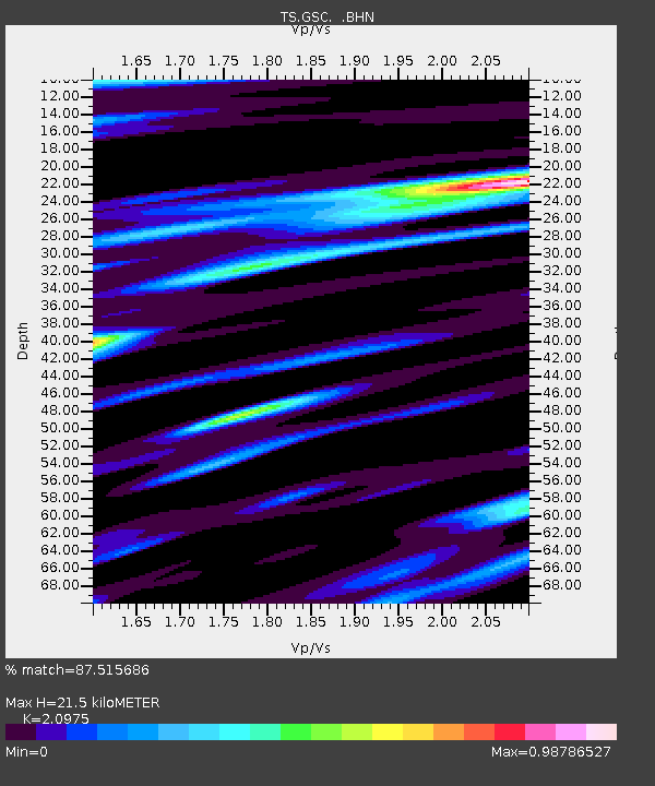
| Estimated Moho Depth: |
21.5 km |
| Estimated Crust Vp/Vs: |
2.10 |
| Assumed Crust Vp: |
6.276 km/s |
| Estimated Crust Vs: |
2.992 km/s |
| Estimated Crust Poisson's Ratio: |
0.35 |
|
| Radial Match: |
87.515686 % |
| Radial Bump: |
400 |
| Transverse Match: |
78.8121 % |
| Transverse Bump: |
400 |
| SOD ConfigId: |
6273 |
| Insert Time: |
2010-02-26 14:17:50.521 +0000 |
| GWidth: |
2.5 |
| Max Bumps: |
400 |
| Tol: |
0.001 |
|

Signal To Noise
| Channel | StoN | STA | LTA |
| TS:GSC: :BHN:19960317T15:00:53.502002Z | 2.0334978 | 2.9504898E-7 | 1.4509432E-7 |
| TS:GSC: :BHE:19960317T15:00:53.502002Z | 2.606844 | 4.6672028E-7 | 1.7903652E-7 |
| TS:GSC: :BHZ:19960317T15:00:53.502002Z | 7.5468636 | 1.6610076E-6 | 2.2009243E-7 |
| Arrivals |
| Ps | 3.8 SECOND |
| PpPs | 10 SECOND |
| PsPs/PpSs | 14 SECOND |


