You are here: Home > Network List > TA - USArray Transportable Network (new EarthScope stations) Stations List
> Station C23A Lambert, MT, USA > Earthquake Result Viewer
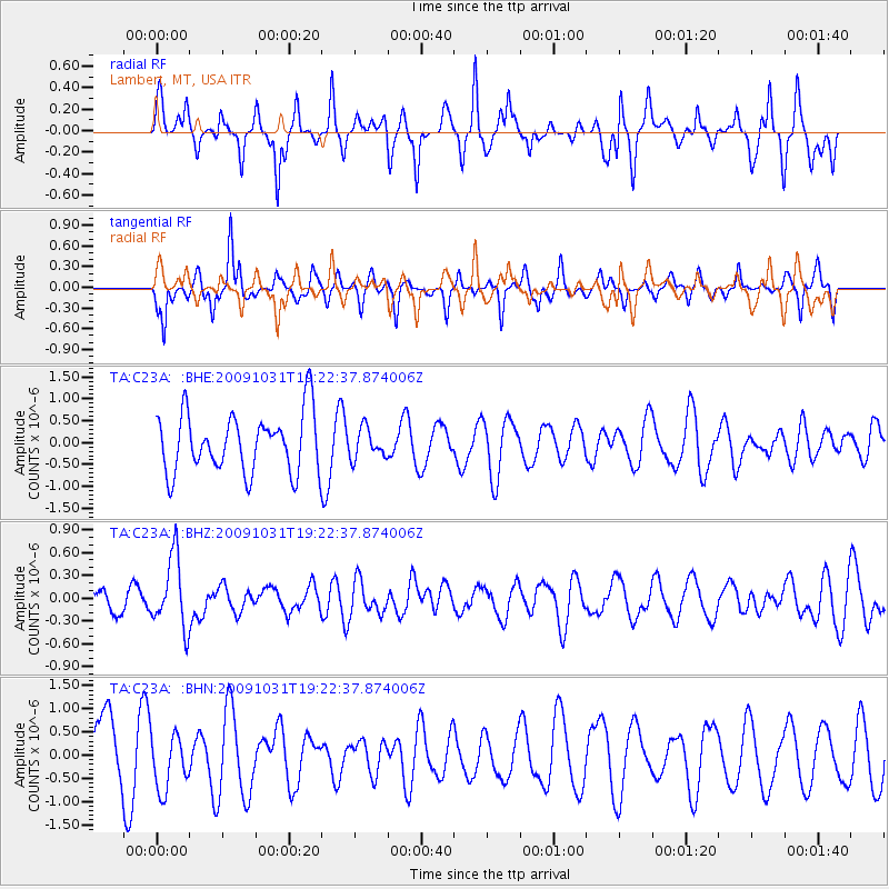
C23A Lambert, MT, USA - Earthquake Result Viewer
*The percent match for this event was below the threshold and hence no stack was calculated.
| Earthquake location: |
Santa Cruz Islands |
| Earthquake latitude/longitude: |
-11.4/166.4 |
| Earthquake time(UTC): |
2009/10/31 (304) 19:09:51 GMT |
| Earthquake Depth: |
134 km |
| Earthquake Magnitude: |
5.9 MB, 5.9 MW, 5.9 MW |
| Earthquake Catalog/Contributor: |
WHDF/NEIC |
|
| Network: |
TA USArray Transportable Network (new EarthScope stations) |
| Station: |
C23A Lambert, MT, USA |
| Lat/Lon: |
47.80 N/105.18 W |
| Elevation: |
729 m |
|
| Distance: |
97.3 deg |
| Az: |
42.796 deg |
| Baz: |
261.195 deg |
| Ray Param: |
$rayparam |
*The percent match for this event was below the threshold and hence was not used in the summary stack. |
|
| Radial Match: |
51.333942 % |
| Radial Bump: |
319 |
| Transverse Match: |
46.400368 % |
| Transverse Bump: |
294 |
| SOD ConfigId: |
2622 |
| Insert Time: |
2010-03-07 00:17:03.359 +0000 |
| GWidth: |
2.5 |
| Max Bumps: |
400 |
| Tol: |
0.001 |
|
Signal To Noise
| Channel | StoN | STA | LTA |
| TA:C23A: :BHZ:20091031T19:22:37.874006Z | 2.2166076 | 4.6696653E-7 | 2.1066722E-7 |
| TA:C23A: :BHN:20091031T19:22:37.874006Z | 0.77546066 | 6.1145715E-7 | 7.885083E-7 |
| TA:C23A: :BHE:20091031T19:22:37.874006Z | 0.5038429 | 3.4080938E-7 | 6.764199E-7 |
| Arrivals |
| Ps | |
| PpPs | |
| PsPs/PpSs | |


