You are here: Home > Network List > TA - USArray Transportable Network (new EarthScope stations) Stations List
> Station C23A Lambert, MT, USA > Earthquake Result Viewer
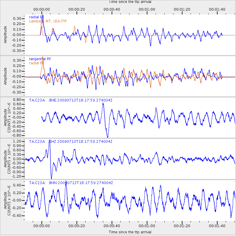
C23A Lambert, MT, USA - Earthquake Result Viewer
*The percent match for this event was below the threshold and hence no stack was calculated.
| Earthquake location: |
Taiwan Region |
| Earthquake latitude/longitude: |
24.1/122.2 |
| Earthquake time(UTC): |
2009/07/13 (194) 18:05:01 GMT |
| Earthquake Depth: |
17 km |
| Earthquake Magnitude: |
6.1 MB, 6.3 MS, 6.3 MW, 6.2 MW |
| Earthquake Catalog/Contributor: |
WHDF/NEIC |
|
| Network: |
TA USArray Transportable Network (new EarthScope stations) |
| Station: |
C23A Lambert, MT, USA |
| Lat/Lon: |
47.80 N/105.18 W |
| Elevation: |
729 m |
|
| Distance: |
96.8 deg |
| Az: |
29.975 deg |
| Baz: |
317.353 deg |
| Ray Param: |
$rayparam |
*The percent match for this event was below the threshold and hence was not used in the summary stack. |
|
| Radial Match: |
63.541836 % |
| Radial Bump: |
294 |
| Transverse Match: |
49.518875 % |
| Transverse Bump: |
378 |
| SOD ConfigId: |
2648 |
| Insert Time: |
2010-03-07 00:17:33.725 +0000 |
| GWidth: |
2.5 |
| Max Bumps: |
400 |
| Tol: |
0.001 |
|
Signal To Noise
| Channel | StoN | STA | LTA |
| TA:C23A: :BHZ:20090713T18:17:59.274004Z | 7.3654685 | 5.2729274E-7 | 7.1589845E-8 |
| TA:C23A: :BHN:20090713T18:17:59.274004Z | 2.4305115 | 2.3638657E-7 | 9.725796E-8 |
| TA:C23A: :BHE:20090713T18:17:59.274004Z | 1.8995622 | 2.1846009E-7 | 1.1500549E-7 |
| Arrivals |
| Ps | |
| PpPs | |
| PsPs/PpSs | |


