You are here: Home > Network List > TA - USArray Transportable Network (new EarthScope stations) Stations List
> Station C23A Lambert, MT, USA > Earthquake Result Viewer
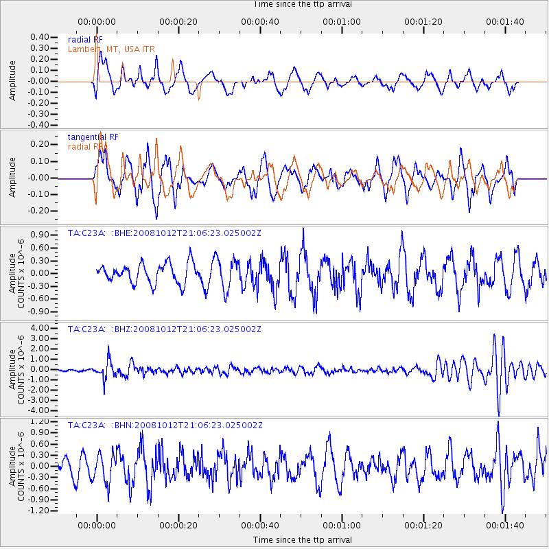
C23A Lambert, MT, USA - Earthquake Result Viewer
*The percent match for this event was below the threshold and hence no stack was calculated.
| Earthquake location: |
Southern Bolivia |
| Earthquake latitude/longitude: |
-20.1/-65.0 |
| Earthquake time(UTC): |
2008/10/12 (286) 20:55:41 GMT |
| Earthquake Depth: |
353 km |
| Earthquake Magnitude: |
6.0 MB, 6.2 MW, 6.2 MW |
| Earthquake Catalog/Contributor: |
WHDF/NEIC |
|
| Network: |
TA USArray Transportable Network (new EarthScope stations) |
| Station: |
C23A Lambert, MT, USA |
| Lat/Lon: |
47.80 N/105.18 W |
| Elevation: |
729 m |
|
| Distance: |
76.6 deg |
| Az: |
333.424 deg |
| Baz: |
141.421 deg |
| Ray Param: |
$rayparam |
*The percent match for this event was below the threshold and hence was not used in the summary stack. |
|
| Radial Match: |
61.457687 % |
| Radial Bump: |
400 |
| Transverse Match: |
54.72478 % |
| Transverse Bump: |
400 |
| SOD ConfigId: |
2556 |
| Insert Time: |
2010-03-07 00:17:42.956 +0000 |
| GWidth: |
2.5 |
| Max Bumps: |
400 |
| Tol: |
0.001 |
|
Signal To Noise
| Channel | StoN | STA | LTA |
| TA:C23A: :BHZ:20081012T21:06:23.025002Z | 6.583147 | 8.416259E-7 | 1.2784552E-7 |
| TA:C23A: :BHN:20081012T21:06:23.025002Z | 1.3092916 | 3.7612998E-7 | 2.872775E-7 |
| TA:C23A: :BHE:20081012T21:06:23.025002Z | 1.6126691 | 3.683382E-7 | 2.2840284E-7 |
| Arrivals |
| Ps | |
| PpPs | |
| PsPs/PpSs | |


