You are here: Home > Network List > TA - USArray Transportable Network (new EarthScope stations) Stations List
> Station C23A Lambert, MT, USA > Earthquake Result Viewer
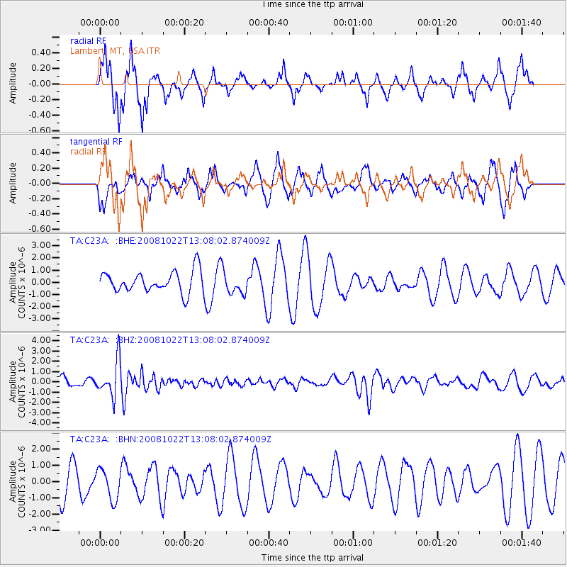
C23A Lambert, MT, USA - Earthquake Result Viewer
*The percent match for this event was below the threshold and hence no stack was calculated.
| Earthquake location: |
Tonga Islands |
| Earthquake latitude/longitude: |
-18.4/-175.4 |
| Earthquake time(UTC): |
2008/10/22 (296) 12:55:57 GMT |
| Earthquake Depth: |
233 km |
| Earthquake Magnitude: |
5.9 MB, 6.4 MW, 6.3 MW |
| Earthquake Catalog/Contributor: |
WHDF/NEIC |
|
| Network: |
TA USArray Transportable Network (new EarthScope stations) |
| Station: |
C23A Lambert, MT, USA |
| Lat/Lon: |
47.80 N/105.18 W |
| Elevation: |
729 m |
|
| Distance: |
90.8 deg |
| Az: |
39.364 deg |
| Baz: |
243.28 deg |
| Ray Param: |
$rayparam |
*The percent match for this event was below the threshold and hence was not used in the summary stack. |
|
| Radial Match: |
54.836872 % |
| Radial Bump: |
233 |
| Transverse Match: |
51.307312 % |
| Transverse Bump: |
324 |
| SOD ConfigId: |
2560 |
| Insert Time: |
2010-03-07 00:17:49.052 +0000 |
| GWidth: |
2.5 |
| Max Bumps: |
400 |
| Tol: |
0.001 |
|
Signal To Noise
| Channel | StoN | STA | LTA |
| TA:C23A: :BHZ:20081022T13:08:02.874009Z | 4.9693594 | 1.7938122E-6 | 3.6097455E-7 |
| TA:C23A: :BHN:20081022T13:08:02.874009Z | 1.2015294 | 9.676482E-7 | 8.053471E-7 |
| TA:C23A: :BHE:20081022T13:08:02.874009Z | 0.9942313 | 8.661508E-7 | 8.711763E-7 |
| Arrivals |
| Ps | |
| PpPs | |
| PsPs/PpSs | |


