You are here: Home > Network List > TA - USArray Transportable Network (new EarthScope stations) Stations List
> Station C23A Lambert, MT, USA > Earthquake Result Viewer
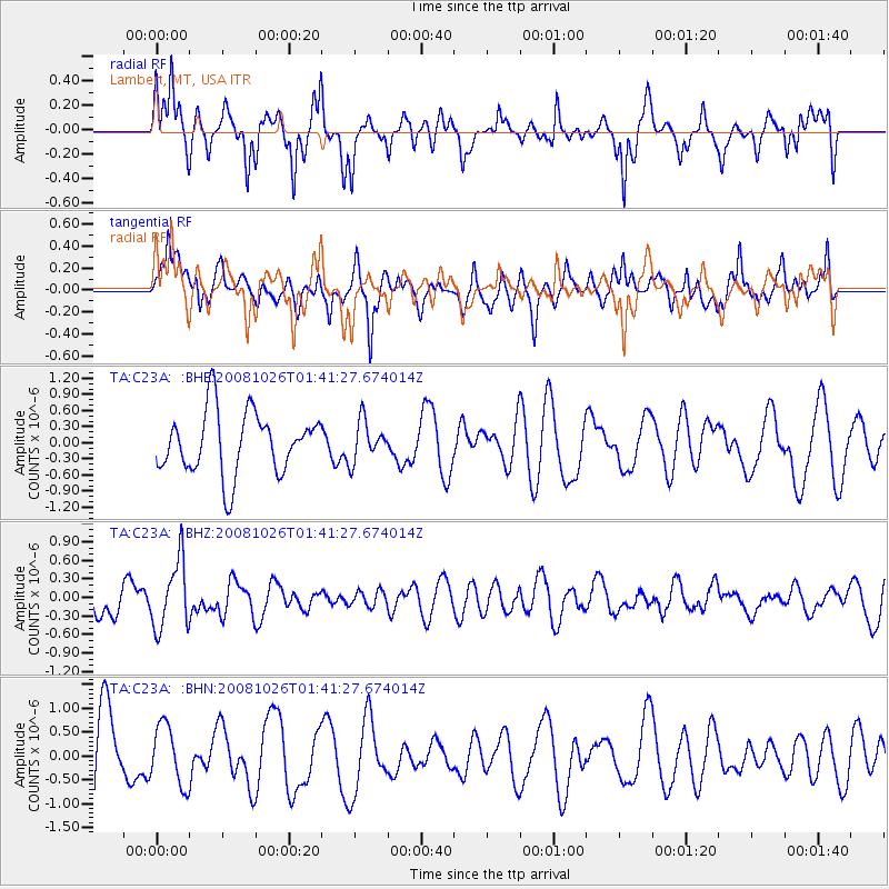
C23A Lambert, MT, USA - Earthquake Result Viewer
*The percent match for this event was below the threshold and hence no stack was calculated.
| Earthquake location: |
Hindu Kush Region, Afghanistan |
| Earthquake latitude/longitude: |
36.5/70.7 |
| Earthquake time(UTC): |
2008/10/26 (300) 01:28:56 GMT |
| Earthquake Depth: |
210 km |
| Earthquake Magnitude: |
5.5 MB, 5.7 MW, 5.7 MW |
| Earthquake Catalog/Contributor: |
WHDF/NEIC |
|
| Network: |
TA USArray Transportable Network (new EarthScope stations) |
| Station: |
C23A Lambert, MT, USA |
| Lat/Lon: |
47.80 N/105.18 W |
| Elevation: |
729 m |
|
| Distance: |
96.0 deg |
| Az: |
357.2 deg |
| Baz: |
3.348 deg |
| Ray Param: |
$rayparam |
*The percent match for this event was below the threshold and hence was not used in the summary stack. |
|
| Radial Match: |
57.632347 % |
| Radial Bump: |
351 |
| Transverse Match: |
56.53769 % |
| Transverse Bump: |
384 |
| SOD ConfigId: |
2560 |
| Insert Time: |
2010-03-07 00:17:50.542 +0000 |
| GWidth: |
2.5 |
| Max Bumps: |
400 |
| Tol: |
0.001 |
|
Signal To Noise
| Channel | StoN | STA | LTA |
| TA:C23A: :BHZ:20081026T01:41:27.674014Z | 2.3960621 | 5.523155E-7 | 2.3050967E-7 |
| TA:C23A: :BHN:20081026T01:41:27.674014Z | 0.6714226 | 6.2401995E-7 | 9.293996E-7 |
| TA:C23A: :BHE:20081026T01:41:27.674014Z | 0.65199137 | 3.7306796E-7 | 5.7219773E-7 |
| Arrivals |
| Ps | |
| PpPs | |
| PsPs/PpSs | |


