You are here: Home > Network List > TA - USArray Transportable Network (new EarthScope stations) Stations List
> Station A20A Cobblestone Ranch, Loring, MT, USA > Earthquake Result Viewer
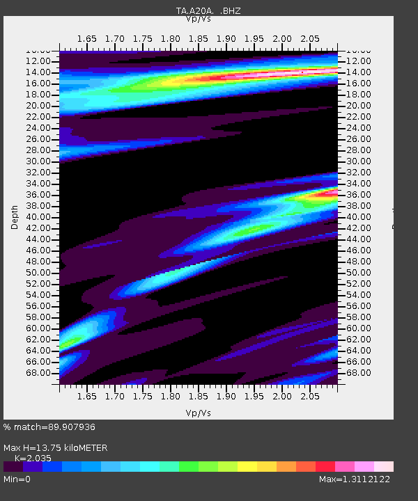
A20A Cobblestone Ranch, Loring, MT, USA - Earthquake Result Viewer
| Earthquake location: |
Vanuatu Islands |
| Earthquake latitude/longitude: |
-13.0/166.5 |
| Earthquake time(UTC): |
2009/10/07 (280) 22:03:14 GMT |
| Earthquake Depth: |
45 km |
| Earthquake Magnitude: |
6.4 MB, 7.3 MS, 7.6 MW, 7.7 MW |
| Earthquake Catalog/Contributor: |
WHDF/NEIC |
|
| Network: |
TA USArray Transportable Network (new EarthScope stations) |
| Station: |
A20A Cobblestone Ranch, Loring, MT, USA |
| Lat/Lon: |
48.88 N/107.93 W |
| Elevation: |
868 m |
|
| Distance: |
96.8 deg |
| Az: |
41.515 deg |
| Baz: |
258.13 deg |
| Ray Param: |
0.04038289 |
| Estimated Moho Depth: |
13.75 km |
| Estimated Crust Vp/Vs: |
2.04 |
| Assumed Crust Vp: |
6.438 km/s |
| Estimated Crust Vs: |
3.163 km/s |
| Estimated Crust Poisson's Ratio: |
0.34 |
|
| Radial Match: |
89.907936 % |
| Radial Bump: |
400 |
| Transverse Match: |
81.141365 % |
| Transverse Bump: |
400 |
| SOD ConfigId: |
2622 |
| Insert Time: |
2010-03-07 00:18:01.792 +0000 |
| GWidth: |
2.5 |
| Max Bumps: |
400 |
| Tol: |
0.001 |
|

Signal To Noise
| Channel | StoN | STA | LTA |
| TA:A20A: :BHZ:20091007T22:16:08.975005Z | 4.883145 | 1.2370858E-6 | 2.5333793E-7 |
| TA:A20A: :BHN:20091007T22:16:08.975005Z | 0.3927895 | 2.2515883E-7 | 5.7323024E-7 |
| TA:A20A: :BHE:20091007T22:16:08.975005Z | 1.2394959 | 4.919366E-7 | 3.968844E-7 |
| Arrivals |
| Ps | 2.2 SECOND |
| PpPs | 6.4 SECOND |
| PsPs/PpSs | 8.6 SECOND |


