You are here: Home > Network List > TA - USArray Transportable Network (new EarthScope stations) Stations List
> Station A20A Cobblestone Ranch, Loring, MT, USA > Earthquake Result Viewer
A20A Cobblestone Ranch, Loring, MT, USA - Earthquake Result Viewer
| Earthquake location: |
Kermadec Islands Region |
| Earthquake latitude/longitude: |
-27.4/-176.3 |
| Earthquake time(UTC): |
2009/02/18 (049) 21:53:45 GMT |
| Earthquake Depth: |
25 km |
| Earthquake Magnitude: |
6.8 MB, 7.2 MS, 6.9 MW, 6.9 MW |
| Earthquake Catalog/Contributor: |
WHDF/NEIC |
|
| Network: |
TA USArray Transportable Network (new EarthScope stations) |
| Station: |
A20A Cobblestone Ranch, Loring, MT, USA |
| Lat/Lon: |
48.88 N/107.93 W |
| Elevation: |
868 m |
|
| Distance: |
97.4 deg |
| Az: |
38.236 deg |
| Baz: |
236.445 deg |
| Ray Param: |
0.04022664 |
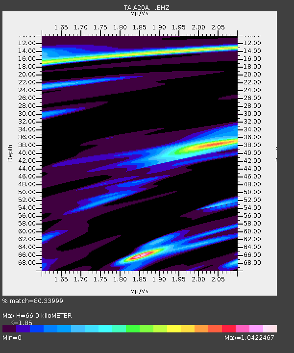
| Estimated Moho Depth: |
66.0 km |
| Estimated Crust Vp/Vs: |
1.85 |
| Assumed Crust Vp: |
6.438 km/s |
| Estimated Crust Vs: |
3.48 km/s |
| Estimated Crust Poisson's Ratio: |
0.29 |
|
| Radial Match: |
80.33999 % |
| Radial Bump: |
220 |
| Transverse Match: |
80.83546 % |
| Transverse Bump: |
289 |
| SOD ConfigId: |
2658 |
| Insert Time: |
2010-03-07 00:18:09.088 +0000 |
| GWidth: |
2.5 |
| Max Bumps: |
400 |
| Tol: |
0.001 |
|

Signal To Noise
| Channel | StoN | STA | LTA |
| TA:A20A: :BHZ:20090218T22:06:44.550015Z | 3.2958224 | 8.458027E-7 | 2.566287E-7 |
| TA:A20A: :BHN:20090218T22:06:44.550015Z | 0.82370144 | 4.971934E-7 | 6.036088E-7 |
| TA:A20A: :BHE:20090218T22:06:44.550015Z | 1.3423682 | 1.0454213E-6 | 7.787888E-7 |
| Arrivals |
| Ps | 8.9 SECOND |
| PpPs | 29 SECOND |
| PsPs/PpSs | 38 SECOND |


