You are here: Home > Network List > TA - USArray Transportable Network (new EarthScope stations) Stations List
> Station O15K Ungalikthiuk River, AK, USA > Earthquake Result Viewer
O15K Ungalikthiuk River, AK, USA - Earthquake Result Viewer
| Earthquake location: |
Kermadec Islands, New Zealand |
| Earthquake latitude/longitude: |
-30.8/-177.4 |
| Earthquake time(UTC): |
2019/06/21 (172) 08:37:20 GMT |
| Earthquake Depth: |
35 km |
| Earthquake Magnitude: |
6.2 Mww |
| Earthquake Catalog/Contributor: |
NEIC PDE/us |
|
| Network: |
TA USArray Transportable Network (new EarthScope stations) |
| Station: |
O15K Ungalikthiuk River, AK, USA |
| Lat/Lon: |
59.18 N/159.82 W |
| Elevation: |
306 m |
|
| Distance: |
90.8 deg |
| Az: |
8.956 deg |
| Baz: |
195.076 deg |
| Ray Param: |
0.041640416 |
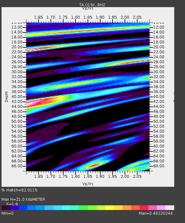
| Estimated Moho Depth: |
21.0 km |
| Estimated Crust Vp/Vs: |
1.60 |
| Assumed Crust Vp: |
6.24 km/s |
| Estimated Crust Vs: |
3.9 km/s |
| Estimated Crust Poisson's Ratio: |
0.18 |
|
| Radial Match: |
82.0115 % |
| Radial Bump: |
400 |
| Transverse Match: |
66.877594 % |
| Transverse Bump: |
400 |
| SOD ConfigId: |
18369291 |
| Insert Time: |
2019-07-05 08:43:18.154 +0000 |
| GWidth: |
2.5 |
| Max Bumps: |
400 |
| Tol: |
0.001 |
|

Signal To Noise
| Channel | StoN | STA | LTA |
| TA:O15K: :BHZ:20190621T08:49:49.174973Z | 4.1157675 | 2.4831292E-7 | 6.03321E-8 |
| TA:O15K: :BHN:20190621T08:49:49.174973Z | 1.9588357 | 7.7521065E-8 | 3.957507E-8 |
| TA:O15K: :BHE:20190621T08:49:49.174973Z | 1.4715723 | 6.4361714E-8 | 4.37367E-8 |
| Arrivals |
| Ps | 2.1 SECOND |
| PpPs | 8.6 SECOND |
| PsPs/PpSs | 11 SECOND |


