You are here: Home > Network List > TA - USArray Transportable Network (new EarthScope stations) Stations List
> Station A20A Cobblestone Ranch, Loring, MT, USA > Earthquake Result Viewer
A20A Cobblestone Ranch, Loring, MT, USA - Earthquake Result Viewer

| Earthquake location: |
Kuril Islands |
| Earthquake latitude/longitude: |
46.0/151.5 |
| Earthquake time(UTC): |
2009/04/07 (097) 04:23:33 GMT |
| Earthquake Depth: |
31 km |
| Earthquake Magnitude: |
6.5 MB, 6.8 MS, 6.9 MW, 6.9 MW |
| Earthquake Catalog/Contributor: |
WHDF/NEIC |
|
| Network: |
TA USArray Transportable Network (new EarthScope stations) |
| Station: |
A20A Cobblestone Ranch, Loring, MT, USA |
| Lat/Lon: |
48.88 N/107.93 W |
| Elevation: |
868 m |
|
| Distance: |
62.9 deg |
| Az: |
46.791 deg |
| Baz: |
309.74 deg |
| Ray Param: |
0.059854757 |
| Estimated Moho Depth: |
18.75 km |
| Estimated Crust Vp/Vs: |
1.61 |
| Assumed Crust Vp: |
6.438 km/s |
| Estimated Crust Vs: |
4.011 km/s |
| Estimated Crust Poisson's Ratio: |
0.18 |
|
| Radial Match: |
96.19055 % |
| Radial Bump: |
312 |
| Transverse Match: |
89.88067 % |
| Transverse Bump: |
400 |
| SOD ConfigId: |
2658 |
| Insert Time: |
2010-03-07 00:18:18.885 +0000 |
| GWidth: |
2.5 |
| Max Bumps: |
400 |
| Tol: |
0.001 |
|
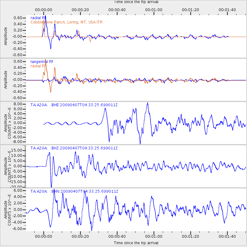
Signal To Noise
| Channel | StoN | STA | LTA |
| TA:A20A: :BHZ:20090407T04:33:25.699011Z | 35.141632 | 8.6988375E-6 | 2.4753652E-7 |
| TA:A20A: :BHN:20090407T04:33:25.699011Z | 4.4081745 | 2.4395874E-6 | 5.534235E-7 |
| TA:A20A: :BHE:20090407T04:33:25.699011Z | 7.964009 | 3.0038696E-6 | 3.7718058E-7 |
| Arrivals |
| Ps | 1.9 SECOND |
| PpPs | 7.2 SECOND |
| PsPs/PpSs | 9.1 SECOND |


