You are here: Home > Network List > TA - USArray Transportable Network (new EarthScope stations) Stations List
> Station A20A Cobblestone Ranch, Loring, MT, USA > Earthquake Result Viewer
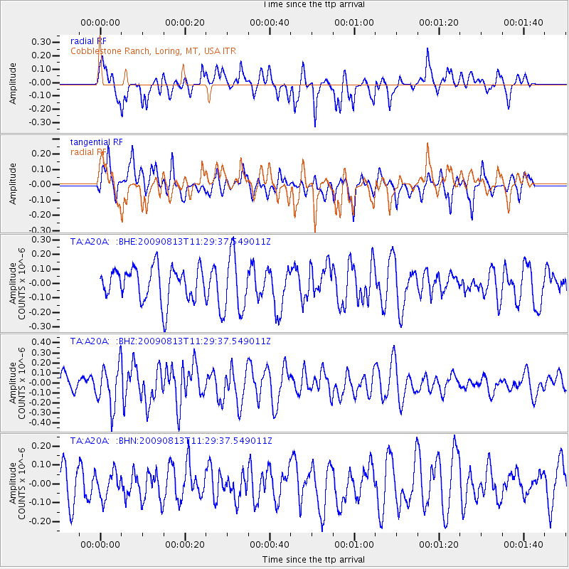
A20A Cobblestone Ranch, Loring, MT, USA - Earthquake Result Viewer
*The percent match for this event was below the threshold and hence no stack was calculated.
| Earthquake location: |
Tonga Islands |
| Earthquake latitude/longitude: |
-21.7/-174.6 |
| Earthquake time(UTC): |
2009/08/13 (225) 11:17:01 GMT |
| Earthquake Depth: |
10 km |
| Earthquake Magnitude: |
5.6 MW, 5.3 MB |
| Earthquake Catalog/Contributor: |
WHDF/NEIC |
|
| Network: |
TA USArray Transportable Network (new EarthScope stations) |
| Station: |
A20A Cobblestone Ranch, Loring, MT, USA |
| Lat/Lon: |
48.88 N/107.93 W |
| Elevation: |
868 m |
|
| Distance: |
91.8 deg |
| Az: |
37.326 deg |
| Baz: |
238.695 deg |
| Ray Param: |
$rayparam |
*The percent match for this event was below the threshold and hence was not used in the summary stack. |
|
| Radial Match: |
59.07698 % |
| Radial Bump: |
400 |
| Transverse Match: |
47.53597 % |
| Transverse Bump: |
366 |
| SOD ConfigId: |
2622 |
| Insert Time: |
2010-03-07 00:18:38.146 +0000 |
| GWidth: |
2.5 |
| Max Bumps: |
400 |
| Tol: |
0.001 |
|
Signal To Noise
| Channel | StoN | STA | LTA |
| TA:A20A: :BHZ:20090813T11:29:37.549011Z | 2.8136473 | 2.1069424E-7 | 7.488296E-8 |
| TA:A20A: :BHN:20090813T11:29:37.549011Z | 0.7315037 | 6.680847E-8 | 9.133032E-8 |
| TA:A20A: :BHE:20090813T11:29:37.549011Z | 1.7375929 | 1.9832142E-7 | 1.1413572E-7 |
| Arrivals |
| Ps | |
| PpPs | |
| PsPs/PpSs | |


