You are here: Home > Network List > TA - USArray Transportable Network (new EarthScope stations) Stations List
> Station A20A Cobblestone Ranch, Loring, MT, USA > Earthquake Result Viewer
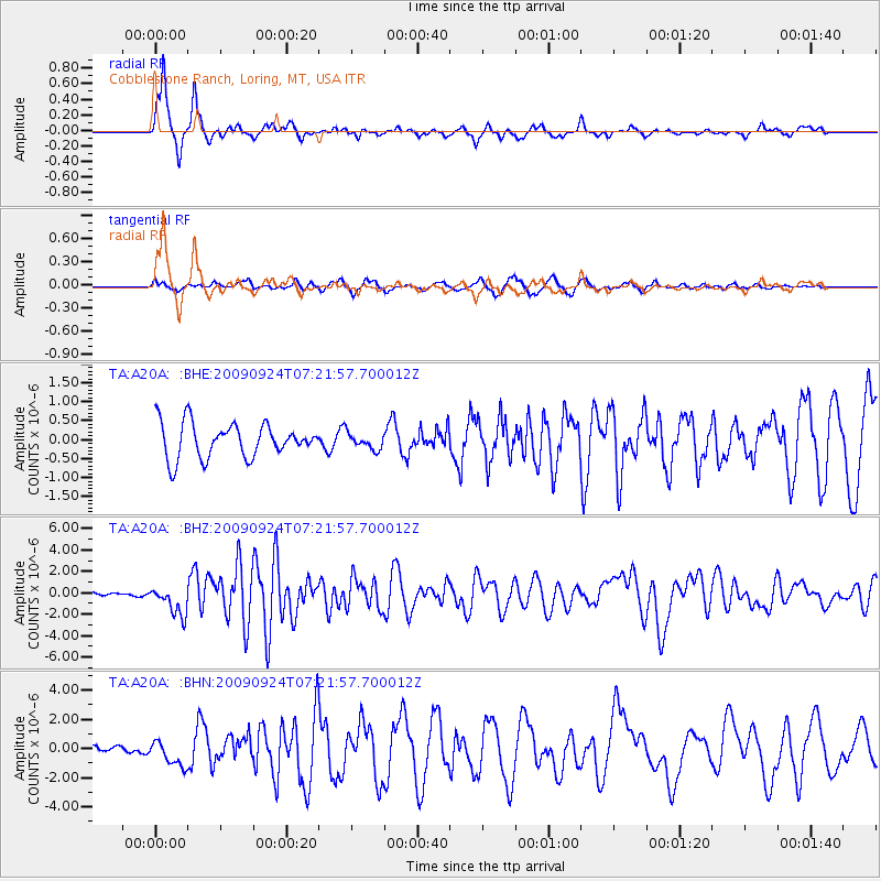
A20A Cobblestone Ranch, Loring, MT, USA - Earthquake Result Viewer
*The percent match for this event was below the threshold and hence no stack was calculated.
| Earthquake location: |
Off Coast Of Jalisco, Mexico |
| Earthquake latitude/longitude: |
18.8/-107.3 |
| Earthquake time(UTC): |
2009/09/24 (267) 07:16:19 GMT |
| Earthquake Depth: |
10 km |
| Earthquake Magnitude: |
5.8 MB, 6.2 MS, 6.3 MW, 6.3 MW |
| Earthquake Catalog/Contributor: |
WHDF/NEIC |
|
| Network: |
TA USArray Transportable Network (new EarthScope stations) |
| Station: |
A20A Cobblestone Ranch, Loring, MT, USA |
| Lat/Lon: |
48.88 N/107.93 W |
| Elevation: |
868 m |
|
| Distance: |
30.0 deg |
| Az: |
359.233 deg |
| Baz: |
178.9 deg |
| Ray Param: |
$rayparam |
*The percent match for this event was below the threshold and hence was not used in the summary stack. |
|
| Radial Match: |
88.53497 % |
| Radial Bump: |
244 |
| Transverse Match: |
63.48811 % |
| Transverse Bump: |
365 |
| SOD ConfigId: |
2622 |
| Insert Time: |
2010-03-07 00:18:58.996 +0000 |
| GWidth: |
2.5 |
| Max Bumps: |
400 |
| Tol: |
0.001 |
|
Signal To Noise
| Channel | StoN | STA | LTA |
| TA:A20A: :BHZ:20090924T07:21:57.700012Z | 9.788979 | 1.3781092E-6 | 1.4078171E-7 |
| TA:A20A: :BHN:20090924T07:21:57.700012Z | 2.2135751 | 8.743805E-7 | 3.9500824E-7 |
| TA:A20A: :BHE:20090924T07:21:57.700012Z | 0.44745162 | 2.0180649E-7 | 4.5101297E-7 |
| Arrivals |
| Ps | |
| PpPs | |
| PsPs/PpSs | |


