You are here: Home > Network List > IU - Global Seismograph Network (GSN - IRIS/USGS) Stations List
> Station POHA Pohakuloa, Hawaii, USA > Earthquake Result Viewer
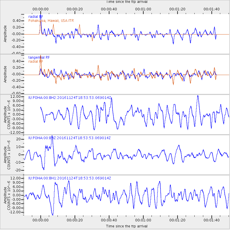
POHA Pohakuloa, Hawaii, USA - Earthquake Result Viewer
*The percent match for this event was below the threshold and hence no stack was calculated.
| Earthquake location: |
Off Coast Of Central America |
| Earthquake latitude/longitude: |
12.0/-88.8 |
| Earthquake time(UTC): |
2016/11/24 (329) 18:43:48 GMT |
| Earthquake Depth: |
10 km |
| Earthquake Magnitude: |
7.0 MWW, 6.7 MWB, 7.2 MI |
| Earthquake Catalog/Contributor: |
NEIC PDE/NEIC COMCAT |
|
| Network: |
IU Global Seismograph Network (GSN - IRIS/USGS) |
| Station: |
POHA Pohakuloa, Hawaii, USA |
| Lat/Lon: |
19.76 N/155.53 W |
| Elevation: |
1990 m |
|
| Distance: |
64.3 deg |
| Az: |
286.249 deg |
| Baz: |
85.937 deg |
| Ray Param: |
$rayparam |
*The percent match for this event was below the threshold and hence was not used in the summary stack. |
|
| Radial Match: |
58.797913 % |
| Radial Bump: |
400 |
| Transverse Match: |
59.049694 % |
| Transverse Bump: |
400 |
| SOD ConfigId: |
1858631 |
| Insert Time: |
2016-12-08 18:46:10.680 +0000 |
| GWidth: |
2.5 |
| Max Bumps: |
400 |
| Tol: |
0.001 |
|
Signal To Noise
| Channel | StoN | STA | LTA |
| IU:POHA:00:BHZ:20161124T18:53:53.069014Z | 2.689944 | 1.0151133E-5 | 3.773734E-6 |
| IU:POHA:00:BH1:20161124T18:53:53.069014Z | 1.5665426 | 3.3564168E-6 | 2.1425633E-6 |
| IU:POHA:00:BH2:20161124T18:53:53.069014Z | 1.4549328 | 5.166763E-6 | 3.5512037E-6 |
| Arrivals |
| Ps | |
| PpPs | |
| PsPs/PpSs | |


