You are here: Home > Network List > TA - USArray Transportable Network (new EarthScope stations) Stations List
> Station A20A Cobblestone Ranch, Loring, MT, USA > Earthquake Result Viewer
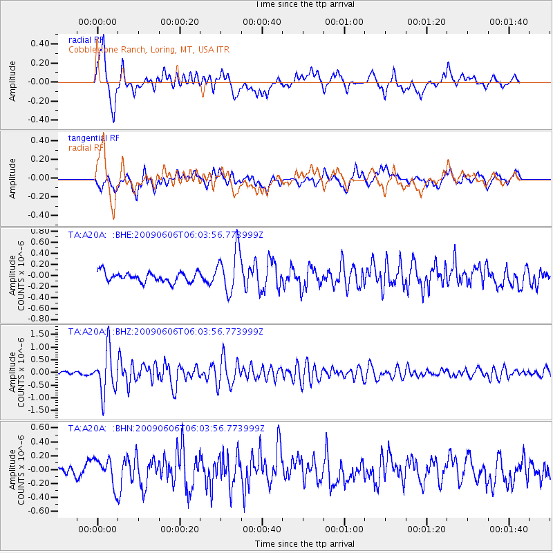
A20A Cobblestone Ranch, Loring, MT, USA - Earthquake Result Viewer
*The percent match for this event was below the threshold and hence no stack was calculated.
| Earthquake location: |
Near East Coast Of Honshu, Japan |
| Earthquake latitude/longitude: |
35.5/140.9 |
| Earthquake time(UTC): |
2009/06/06 (157) 05:52:43 GMT |
| Earthquake Depth: |
34 km |
| Earthquake Magnitude: |
5.8 MB, 5.4 MS, 5.8 MW, 5.7 MW |
| Earthquake Catalog/Contributor: |
WHDF/NEIC |
|
| Network: |
TA USArray Transportable Network (new EarthScope stations) |
| Station: |
A20A Cobblestone Ranch, Loring, MT, USA |
| Lat/Lon: |
48.88 N/107.93 W |
| Elevation: |
868 m |
|
| Distance: |
76.1 deg |
| Az: |
39.353 deg |
| Baz: |
308.378 deg |
| Ray Param: |
$rayparam |
*The percent match for this event was below the threshold and hence was not used in the summary stack. |
|
| Radial Match: |
76.318855 % |
| Radial Bump: |
400 |
| Transverse Match: |
64.99507 % |
| Transverse Bump: |
400 |
| SOD ConfigId: |
2648 |
| Insert Time: |
2010-03-07 00:19:29.142 +0000 |
| GWidth: |
2.5 |
| Max Bumps: |
400 |
| Tol: |
0.001 |
|
Signal To Noise
| Channel | StoN | STA | LTA |
| TA:A20A: :BHZ:20090606T06:03:56.773999Z | 14.7310705 | 8.726569E-7 | 5.9239206E-8 |
| TA:A20A: :BHN:20090606T06:03:56.773999Z | 1.7100544 | 1.987012E-7 | 1.16195835E-7 |
| TA:A20A: :BHE:20090606T06:03:56.773999Z | 4.549977 | 4.0226206E-7 | 8.840969E-8 |
| Arrivals |
| Ps | |
| PpPs | |
| PsPs/PpSs | |


