You are here: Home > Network List > TA - USArray Transportable Network (new EarthScope stations) Stations List
> Station A20A Cobblestone Ranch, Loring, MT, USA > Earthquake Result Viewer
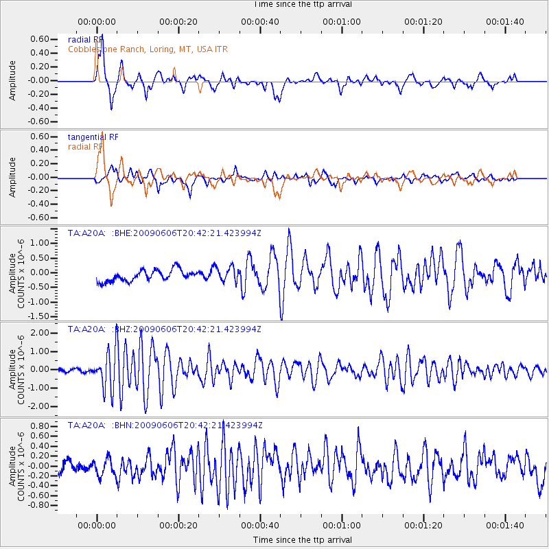
A20A Cobblestone Ranch, Loring, MT, USA - Earthquake Result Viewer
*The percent match for this event was below the threshold and hence no stack was calculated.
| Earthquake location: |
Northern Mid-Atlantic Ridge |
| Earthquake latitude/longitude: |
23.9/-46.1 |
| Earthquake time(UTC): |
2009/06/06 (157) 20:33:28 GMT |
| Earthquake Depth: |
14 km |
| Earthquake Magnitude: |
6.0 MB, 5.7 MS, 6.0 MW, 6.0 MW |
| Earthquake Catalog/Contributor: |
WHDF/NEIC |
|
| Network: |
TA USArray Transportable Network (new EarthScope stations) |
| Station: |
A20A Cobblestone Ranch, Loring, MT, USA |
| Lat/Lon: |
48.88 N/107.93 W |
| Elevation: |
868 m |
|
| Distance: |
54.0 deg |
| Az: |
314.017 deg |
| Baz: |
94.193 deg |
| Ray Param: |
$rayparam |
*The percent match for this event was below the threshold and hence was not used in the summary stack. |
|
| Radial Match: |
84.01298 % |
| Radial Bump: |
400 |
| Transverse Match: |
81.11234 % |
| Transverse Bump: |
400 |
| SOD ConfigId: |
2648 |
| Insert Time: |
2010-03-07 00:19:31.250 +0000 |
| GWidth: |
2.5 |
| Max Bumps: |
400 |
| Tol: |
0.001 |
|
Signal To Noise
| Channel | StoN | STA | LTA |
| TA:A20A: :BHZ:20090606T20:42:21.423994Z | 11.809683 | 1.0440124E-6 | 8.8403084E-8 |
| TA:A20A: :BHN:20090606T20:42:21.423994Z | 1.7985128 | 1.7871145E-7 | 9.936623E-8 |
| TA:A20A: :BHE:20090606T20:42:21.423994Z | 1.2853178 | 2.4447544E-7 | 1.9020624E-7 |
| Arrivals |
| Ps | |
| PpPs | |
| PsPs/PpSs | |


